3. 지도정보 플랫폼(스마트서울맵)
3. Map Information Platform (Smart Seoul Map)
도입배경 및 필요성
Background & Necessity
지도 서비스는 왜 필요할까요? 정보의 80%는 위치 혹은 장소와 관련 있습니다. 그래서 정보를 지도와 결합할 수 있습니다. 특히, 서울시는 마을 주민이 혜택을 누릴 수 있는 다양한 정책을 추진합니다. 또한 스마트기술로 마을 곳곳의 현황정보도 축척하고 있습니다. 이를 수십~수백 장의 보고서가 아닌 지도로 서울시 구성원과 소통하여 이해도를 높일 수 있습니다.
First of all, why do we need map services? About 80% of information is related to location or places. So, information can be combined with maps. In particular, the Seoul Metropolitan Government implements a variety of policies to provide benefits for its citizens. In addition, we are accumulating a wide range of information using smart technologies on a community basis. Such information is produced as maps, instead of dozens or hundreds of pages of reports. We increase our citizens’ understanding, communicating with them using maps.
또한 시민의 지도 활용 수준이 크게 향상되었습니다. 누구나 가지고 있는 스마트폰 GPS 좌표정보와 지도가 결합된 서비스를 이용합니다. 차량용 내비게이션에서부터 가족과 외식, 여행, 이사계획 등 대부분 생활정보를 지도와 결합하여 생활에 활용하고 있습니다.
In addition, citizens’ level of map utilization has greatly enhanced. Smartphone users use GPS information and map-linked services which are very common. They are utilizing such map-linked information services in their daily lives, including GPS navigation systems, family eating out, trips and moving plans.
이처럼 행정서비스도 시민에게 필요한 정책정보를 쉽고 정확하게 전달하는 소통 방법이 필요합니다. 시민 생활 공간에 필요한 정보를 쉽게 알려주기 위해 스마트도시 서울에 맞는 소통행정 혁신을 시작합니다.
Administrative services also need a communication method to deliver policy information required for citizens easily and accurately. We are working on innovation in communication-based administration which fits Smart City Seoul, in order to provide information required for citizens.
정부는 시민에게 쉽고 빠르게 정보를 제공하고, 스마트시티즌이 시정에 참여하고, 이웃과 공유합니다. 즉, 지도와 함께 사용하면 활용성이 높아져서 정보의 가치창출이 향상되고 시민과 소통 강화를 통해 쉽고 빠르게 융합 가능한 행정-공간정보 서비스로 시민소통 행정 혁신을 기대할 수 있습니다.
The government provides information for citizens easily and quickly. Smart citizens participate in administration and share information with their neighbors. In other words, if information is used with maps, it increases applicability and creates more values. By enhancing our communication with citizens, we can expect innovation in civic communication-based administration through administration-space information service which can be easily and quickly combined.
추진내용
Implementation contents
지도정보 플랫폼은 4차산업 신기술과 공간정보를 결합하여 공유와 협업으로 시민삶에 필요한 정보를 활용하고 가치를 창출하고자 합니다. 그래서 서울의 모든 구성원과 장소 혹은 위치와 관련된 시민 생활에 필요한 정보를 모으고 공유하는 초협력의 장을 목표로 합니다.
The map information platform is established to utilize information required for citizens’ daily lives and to create values based on sharing and cooperation by combining spatial information and new technologies of the quaternary sector of the economy. The goal of the map information platform is to create a place for cooperation where all members of Seoul can collect and share spatial or location information required for citizens’ daily lives.
이를 위한 4가지 추진전력의 핵심성공요소는 누구나 쉽고 빠르게 지도 서비스 가능한 서비스 중심의 플랫폼, 표준화된 플랫폼, 개방형 플랫폼 그리고 가치지향 플랫폼을 만드는 것 입니다.
The 4 key success factors of the strategies include a service-oriented platform where everyone can use map services easily and quickly, a standardized platform, an open platform and a value-oriented platform.
첫째, 서비스 가능한 플랫폼은 예산을 들여서 전문인력이 개발하는 서비스가 아니라 비전문가인 업무 담당자나 시민이 직접 자료를 등록하면 스마트폰이나 PC에서 바로 지도 서비스를 만들 수 있는 환경을 제공하는 것입니다.
First, a service-oriented platform is not a service developed by experts with expense. It means providing an environment where non-experts such as government employees and citizens can create map services by entering data in person using their smartphones or PCs.
두번째는 표준화된 플랫폼으로 만들어진 지도서비스나 지도정보가 공유/활용될 때 표준좌표계, 표준파일체계(shp, kml, geoJson 등)로 활용할 수 있습니다.
Second, when map service created in a standardized platform is shared or utilized, it may be utilized as the standard coordinate system and standard file systems (shp, geoJson, etc.).
세번째 성공요소는 서울시 구성원이면 누구나 참여할 수 있는 개방형 플랫폼입니다. 시/자치구 공무원이나 시민활동가 아니면 일반 학생도 플랫폼에 여러 기능을 사용하게 됩니다.
The third key success factor is an open platform that all members of Seoul can take part in. All members of Seoul including employees of the Seoul Metropolitan Government or autonomous districts, citizen activists and even students can use various features of the platform.
마지막으로 앞의 3가지 성공요소를 통해 정보의 가치를 향상됨은 물론 정보의 제공을 넘어서 서울시를 보다 살기 좋은 도시로 만들 수 있는 가치지향형 플랫폼을 말합니다.
The last key success factor is a value-oriented platform. Through the three success factors mentioned earlier, not only does the value-oriented platform enhance and provide information values, but also it makes Seoul a much more livable city.
지도정보 플랫폼 중심의 서비스 인프라 개요를 간단히 말씀드리면, 장소나 위치와 관련된 행정정보, 시민활동가 등 현장수집정보, 시스템에 탑재된 정보를 지도정보 플랫폼에서 표준화된 지도 서비스 체계로 수집, 관리되면, 서울시 대표 지도 포털인 스마트서울맵에서 여러 지도 시각화 기술이 적용된 지도 서비스를 자유롭게 시민이 사용할 수 있습니다.
Let me give you a brief introduction concerning map information platform-centered service infrastructure. The map information platform collects and manages administrative information related to place or location, onsite-collected information gathered by citizen activists, etc., and system information using a standardized map service system. Then, citizens can use a variety of visualization technology-based map services freely in Smart Seoul Map which is a representative map portal of Seoul.
스마트서울맵의 대표 서비스는 도시생활지도 입니다. 각 부서에서 시민을 위해 펼치는 정책과 관련된 정보를 ‘글자’가 아닌 ‘지도’에 표시하여 직접 서비스하고 있습니다. 그와 함께 시민사회나 마을주민이 직접 만들 수 있는 시민참여지도 서비스하고 있습니다.
One of the most representative services of Smart Seoul Map is Urban Life Map. The SMG departments mark information about policies for Seoul citizen on the “map,” instead of writing texts. Smart Seoul Map also provides Citizen Participatory Map which can be created by communities and citizens in person.
참여형 지도서비스 외에 지도정보 플랫폼의 지도 시각화 기능을 활용하여 특정 목적을 가진 서비스를 제공하고 있습니다. 첫째로 서울시 스마트불편신고앱에 신고되는 현장민원(1년 약 50~70만건)과 시민참여예산 사업 분포를 한눈에 확인할 수 있는 시민말씀지도가 있습니다. 그리고 올해 1월부터 발생한 코로나19를 대응하기 위해 선별진료소를 하루만에 지도 서비스로 구축하였고, 방역을 마친 대중이용시설인 클린존 등 관련 정보를 제공하였습니다.
In addition to participatory map services, Smart Seoul Map provides other services of specific purposes using the map information platform’s map visualization feature. Smart Seoul Map provides Voice of Citizen Map. Using this service, you can see citizens’ complaints (approximately 500,000 to 700,000 cases per year) submitted to Seoul Smart Report App, and the distribution of citizen participatory budget projects at a glance. To respond to COVID-19 which has occurred in January 2020, the Seoul Metropolitan Government has established COVID-19 screening station map service in a single day. In addition, COVID-19 information such as clean zones referring to publicly used facilities in which disinfection has been completed has been provided.
스마트서울맵에서는 1972년부터 촬영한 항공사진으로 서울시의 곳곳의 주요 변화지역을 시간순서로 볼 수 있는 서울시 변천사 서비스를 제공하고 있습니다. 또한 앞서 소개한 도시생활지도, 시민참여지도의 콘텐츠와 지도 서비스를 개발할 수 있는 Open API를 제공합니다.
Smart Seoul Map provides Changes in Seoul service. Using this service, you can learn how Seoul has changed by seeing aerial photographs of different places in Seoul, which had been taken since 1972, in chronological order. In addition, Smart Seoul Map has Urban Life Map and Citizen Participatory Map, mentioned earlier, and Open API for map service development.
지금부터 스마트서울맵의 핵심서비인인 도시생활지도 및 시민참여지도의 주요 기능을 설명드리겠습니다. 첫째, 비용없이 빠르게 지도 서비스 제작 기능입니다. 엑셀 등으로 만든 현황자료, GPS 수신기로 조사된 조사자료, 특정 장소가 소개된 홍보자료 그리고 문서나 도면으로 만든 정보 등 장소와 위치와 관련된 정보는 모두 가능합니다.
Now I'd like to give you an overview of Smart Seoul Map’s main services, Urban Life Map and Citizen Participatory Map. First, map services can be created fast without expense. All types of information related to location and places can be used, including facility information in Excel files, etc. data collected from GPS receivers, promotional brochures of specific places and information in documents or drawings.
둘째, 복잡한 정보를 쉽게 한눈에 볼 수 있는 지도 시각화 서비스입니다. 대량의 콘텐츠를 모아서 보여주는 마커클러스터, 콘텐츠의 지역의 분포를 볼 수 있는 히트맵, 행정구역별 분포를 보는 단계구분도, 그리고 시간의 순서로 시각화하는 시계열 지도 서비스를 제공합니다.
Second, it is map visualization service that allows you to see complicated information at a glance. It provides marker clustering of large content, heat maps showing content distribution, choropleth maps for distribution by administrative district and time-series maps for visualization in chronological order.
마지막으로 힘들게 개발하지 않아도 자신의 홈페이지나 블로그, SNS에 공유할 수 있는 지도 공유/활용 서비스 입니다. 도시생활지도 테마전체를 복사하는 테마복사 기능, 특정 콘텐츠만 공유하는 지도 복사, 네이버(블로그, 카페, 뉴스) 연관 정보를 보여주는 원페이맵, 그리고 여러 테마를 묶어서 보여주는 묶음테마복사 기능을 제공하고 있습니다. 특히, 지도 복사 기능을 활용하면 여러 시설의 약도 기능을 대체할 수 있습니다.
The last feature is map sharing and utilization service. You don't have to struggle for development. You can just share information with others via your website, blog or SNS account. You may copy the entire theme of Urban Life Map using the theme copy feature, or share specific content using the map copy feature. One Page Map shows relevant information of NAVER (Blog, Café and News). Lastly, the bundled theme copy feature shows numerous themes in one bundle. In particular, the map copy feature may substitute for the rough maps of numerous facilities.
코로나19 서울지도 서비스는 지도정보 플랫폼을 활용한 사례입니다. 한 눈에 코로나19 관련 정보를 확인할 수 있도록 신규 서비스를 오픈하였고, 서울시 홈페이지 뿐만아니라 내 손안에 서울, 아리수 홈페이지와 연계하여 활동하고 있습니다.
COVID-19 Seoul map service is one of the applications of the map information platform. The Seoul Metropolitan Government has launched this new service so that citizens can see COVID-19 information at a glance. This service is linked to Seoul in My Hand and the Arisu website as well as the SMG website.
지도정보 플랫폼을 활용한 두번째 사례는 최근 이슈가 되고 있는 어린이 보호구역 입니다. 민식이법으로 어린이 보호구역내에서 주정차, 과속 등 규정이 강화되고 있는 실정에서 시민들에게 어린이 보호구역을 명확하게 알리기 위하여 25개 자치구 담당자가 직접 등록하였습니다. 그리고 그 정보는 그대로 민간 내비게이션 업체에 제공되어 운전자에게 안내되고 있습니다.
The second application case of the map information platform is school zones which are recently emerging as a hot issue. As the Min-sik law has been effectuated, the traffic regulations in school zones such as no standing/parking zones and speed limits are strengthened. To inform citizens of school zones clearly, officials from 25 autonomous districts entered information in person. The information is shared with private GPS navigation companies and provided for drivers.
문제점 및 극복방법
Issues & Solutions
대부분 부서에서 지도 활용은 비교적 간단한 위치 안내 서비스입니다. Open API 이용시 사업기획, 예산배정, 사업시행 등으로 최소 1.5년 소요되지만 웹 링크 서비스를 이용하면 2~3일 이내 서비스가 가능해집니다.
Most departments use comparatively simple location information service when they use maps. When an open API is used, it takes at least 1.5 years for project planning, budget compilation and project implementation. However, if web link service is used, it can be done within 2 or 3 days.
또한 매년 사용자의 요구사항이 다양화되어 상용 SW로 개발과 서비스 병행이 어려우나 전세계 개발자가 참여하여 만든 오픈소스 SW 기능을 신속히 활용 가능합니다.
As users’ demands diversify every year, it is getting difficult to develop and provide service at the same time using commercial software. However, you can use open source software swiftly, which is developed by developers all over the world.
도시생활지도의 증가로 주제별로 작게는 20개, 많게는 10,000개 이상 콘텐츠가 상이합니다. 이를 관리하는 방법 역시 다양한데요. 먼저 지도 서비스도 효과적으로 제공이 필요하며, 콘텐츠 관리는 엑셀을 이용하고, 대용량 콘텐츠에 대한 마커클러스터 등 효율적인 지도 시각화를 제공해야 합니다.
As the content increase in Urban Life Map, the number of content range from 20 to 10,000 per theme. Accordingly, there are numerous ways to manage content. First, map services should be provided effectively and content should be managed by Excel. In addition, we should provide efficient map visualization such as marker clustering for large contents.
그리고 시민 접점이 약한 공공 서비스의 한계를 극복하기 위해 시민생활에 필요한 정보를 시민이 쉽게 접근하는 서비스 매체에 제공이 필요하며, 시민이 주로 이용하는 민간 지도(네이버, 카카오 등)과 협약으로 시민 소통을 실현해야 합니다.
To overcome weak citizen touchpoints, which are a limit of public services, we need to provide information required for citizens’ daily lives for easily accessible service media. In addition, we have to communicate with citizens based on a cooperative system with portal map services (NAVER, Kakao, etc.) familiar to citizens.
평가(도입효과)
Evaluation (Effects)
스마트서울맵은 2019년 서울둘레길, 차 없는 거리, 봄꽃길 등 313종 도시생활지도를 제작하였습니다. 별도 구축비용 없이, 단기간에 필요한 지도 서비스 구축으로 신속하게 행정 추진하였습니다.
Smart Seoul Map has created 313 types of urban life maps including 2019 Seoul Trails, Car-Free Streets and Spring Blossom Streets. We made necessary map services in a short period of time without expense for swift administration.
또한 시민 생활에 필요한 행정정보를 지도 서비스를 통해 시민 소통 혁신을 실현하였습니다. 실국·자치구 등 신속한 시민 정보 제공을 위해 스마트서울맵 활용을 촉진하였으며, 네이버, 카카오 등 민간 지도 서비스에서 25종 대시민 서비스를 실시하였습니다.
The Seoul Metropolitan Government has realized innovation in communication with citizens by providing administrative information required for daily lives through map services. We promoted the utilization of Smart Seoul Map to provide information for citizens swiftly in organizations and autonomous districts. In addition, we share 25-type map through portal map services such as NAVER and Kakao.
코로나19 같은 긴급 상황에 필요한 정보를 비예산으로 시민 서비스를 제공하여 지자체 최초로 선별진료소, 신천지 교회 시설 등 지도 서비스 구축 운영하였으며, 추가 예산 없이 2~3일안에 지도 서비스를 제공하였습니다.
The Seoul Metropolitan Government provides information services with no budget in an emergency situation such as COVID-19. We have established and have been providing COVID-19 screening station map and Sincheonji map for the first time among local governments. We could provide such services in a couple of days without any additional budget.
향후계획 및 시사점
Future Plan & Implications
스마트서울맵의 2020년 추진 계획으로 첫째, 다양한 지도 서비스 제공을 위한 지도 시각화 고도화입니다. 오픈소스 SW인 Leaflet0.X 버전을 1.6버전으로 업데이트하고 이동경로나 선형명칭등을 시각화 할 수 있는 기능을 제공할 것입니다.
The first plan in 2020 for Smart Seoul Map is map visualization enhancement to provide a variety of map services. We will update open source SW Leaflet 0.X to 1.6 Version, and provide travel route and street label visualization features.
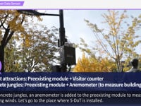
둘째, 시 전역 대기질 정보 지도 시각화 확대를 위해 스마트도시담당관, 대기정책과 등의 협업을 하며, 기존 국가측정망, 간이측정기에 통합센서 추가로 총 1,450개의 정보를 표출하고, 기존측정기 미세먼지, 초미세먼지 2개와 통합센서 소음, 진동 등 10개의 정보를 제공합니다.
Second, the Seoul Metropolitan Government cooperated with the Smart City Policy Bureau and Air Quality Policy Division in order to improve air quality information map visualization in the entire city. Additional integrated sensors were added to the preexisting national measurement network and simplified measuring instruments. As a result, now a total of 1,450 sensors are collected data. The preexisting meters provide ultrafine and fine dust information, and the integrated sensors display 10 types of data including noise and vibrations.
셋째, 30만 그루 가로수 지도 시각화를 통해 지도 레벨에 따라 대용량 지도 콘텐츠 시각화로 안정적 서비스를 제공할 예정입니다. 이는 향후 CCTV, WiFi 등 수만개 이상의 도시시설물을 시각화화는데 참고 사례로 활용될 것입니다.
Third, approximately 300,000 roadside trees will be visualized on the map. We will provide stabilized services by visualizing a large amount of map content depending on different map levels. It could be utilized as a reference for visualization of ten thousands of urban facilities such as surveillance cameras and WiFi.
서울시 활용에 따른 시사점과 해외 적용 가능성을 보면 주소기반 시설현황 정보를 지도로 전환하는 기술은 보편적으로 필요한 기능입니다. 이를 활용하여 ‘문자’로 된 정보를 ‘지도’에 표출하면 정보의 새로운 가치 창출이 가능합니다. 또한 주소체계가 완벽하지 않은 개발도상국의 경우에서 더욱 그 활용도를 느낄 수 있을 것입니다.
Let’s think about Smart Seoul Map’s implications and overseas applicability. Technology converting address-based information into map-based location is universally necessary. By displaying “text” information on the “map” using this technology, you can create new values of information. It will be even more useful in developing countries with an imperfect address system.
더 중요한 요소는 지도 서비스까지 제공해야 담당부서의 참여 확대가 가능하며, Open API로 제공보다 웹링크용 지도 서비스로의 제공이 실무적으로 효과가 극대화됩니다.
Map services should be provided as well to increase relevant departments’ participation. Web link map services can maximize practical effects more than Open API does.
서울시는 개방형, 참여형 지도정보 플랫폼 인프라를 이용하여 “생활밀착형 행정정보”, 현장민원, 참여예산 등 시민의 요구사항을 담은 “시민말씀정보”, IoT센서에서 획득하는 “도시환경정보”를 스마트서울맵에서 다양한 지도 시각화를 활용하여 시민과 소통하고 협력해 나갈 것입니다.
Using this open, participatory map information platform, the Seoul Metropolitan Government will provide “practical administrative information,” “voice of citizen information” showing citizens’ demands such as citizens' voices and participatory budgets," and “urban environmental information” collected from IoT sensors. In addition, we communicate and cooperate with our citizens using various types of map visualizations in Smart Seoul Map.