Seoul Transport Operation & Information Service-TOPIS
4. TOPIS, the Center of Seoul's Intelligent Transportation
4. 서울 지능형교통의 중심, TOPIS
Today, I will be talking about Seoul TOPIS that has become the world's center of intelligence.
세계 지능형의 중심으로 성장한 서울 TOPIS에 대해 말씀드리겠습니다.
Seoul TOPIS started with the introduction of the Traffic Management Service in the area of Namsan Mountain in 1998. As the City Freeway Traffic Management System was first promoted in 2000, starting from the Naebu Express Way, the Intelligent Traffic System (ITS) started expanding in earnest.
서울 지능형교통의 시작은 1998년 남산권 교통관리시스템이 도입된 후 2000년부터 내부순환로를 시작으로 도시고속도로 교통관리시스템이 추진되면서 ITS를 본격적으로 확대하게 됩니다.
With the reorganization of the public traffic system in 2004, Seoul TOPIS was launched and has transformed into an integrated traffic center.
2004년 서울 대중교통체계개편과 함께 오픈했고 하나의 통합 교통센터로 탈바꿈하게 됩니다.
Transportation data was made available to the public in 2009 along with the mobile service.
2009년 모바일 서비스와 함께 전국 최초로 교통데이터를 민간에 개방했습니다.
In 2013, Seoul TOPIS became an integrated city management center that offers not only traffic features but also disaster and preparation for wars and national emergency features. It has been serving as Seoul’s city management control tower.
또한 서울 토피스는 2013년 교통뿐만 아니라, 재난과 충무기능을 결합한 도시관리 통합센터로 발돋움함으로써 서울도시관리 컨트롤타워의 기능을 수행합니다.
Introduction of TOPIS
TOPIS 소개
Currently, TOPIS collects the GPS data of about 70,000 taxis and collects and provides the speed information of roads in real time from 1,955 video detectors installed on site.
토피스는 현재 약 7만대의 택시의 gps데이터를 수집하며 현장에 설치된 영상검지기 1,955개를 통해 도로의 실시간 속도정보를 수집, 제공하고 있습니다.
Also, 849 installed CCTVs are operated to monitor traffic and disaster situations, and 341 VMS and #5 Lane Control System (LCS) are installed and operated in 95 sites.
또한 교통과 재난상황 등 모니터링을 위해 849대의 CCTV를 설치 운영하고 있으며, 341대의 도로전광표지, 95곳에 차로제어시스템(LCS)를 운영하고 있습니다.
The Bus Information Terminal (BIT) was installed in 78.2% of all bus stops to provide citizens with the expected arrival times of buses and subways in real time.
그리고 전체 버스정류소의 78.2%에 버스정보안내단말기(BIT)를 설치하여, 시민들에게 버스 및 지하철 도착시간을 실시간으로 안내하고 있습니다.
The bus arrival information is collected via the cutting-edge BIT installed inside all buses in Seoul. The accuracy of this bus information is about 99%, and 96% of citizens answered that they are satisfied with the information.
버스 도착정보는 서울시 모든 버스에 설치된 최첨단 버스단말기를 통해 수집되며, 버스정보의 정확성은 약 99%, 시민만족도는 96%에 달하고 있습니다.
All information in TOPIS is open to the public. 24 million pieces of information are provided to the public every day through open API.
토피스가 소유한 모든 정보는 민간에 개방되고 있으며, 하루 2천4백만 건에 달하는 정보가 Open API방식으로 민간에 제공됩니다.
About 2,062 foreign officials visit Seoul TOPIS, the center of the world's intelligent transportation, every year.
그리고 세계 지능형교통의 중심, 서울 토피스에 방문하는 외국공무원 등은 연간 약 2,062여명에 이르고 있습니다.
Composition and Main Features of TOPIS
TOPIS의 주요 구성과 기능
Let’s talk about the system of Seoul TOPIS. TOPIS includes the Integrated Center System that integrates and analyzes all traffic information and deals with unexpected situations such as accidents; the Road Traffic Management System that manages the traffic flow, handles traffic speed and volume, and collects unexpected information; and the Bus Information System that manages buses and provides citizens with integrated information on public transportation.
서울 토피스의 시스템에 대해 알아보겠습니다. 토피스는 모든 교통정보를 통합·분석하고, 사고 등 돌발상황을 대응하는 통합센터 시스템, 도시고속도로 차량 흐름을 관리하고, 속도와 교통량, 돌발정보 수집 등을 담당하는 도로교통관리 시스템, 그리고 버스관리 및 대중교통 통합 정보를 시민에게 제공하는 버스정보시스템이 있습니다.
It also offers the Unmanned Regulation and Fine Imposition System that cracks down on illegal parking and stopping, Traffic Forecasting System that supports establishment of transport policies, Traffic Control System that supervises the green transport zone, and C-ITS, totaling to 7 systems. Now, let’s learn more about each system.
또한 불법 주정차 단속을 하는 무인단속 및 과태료 부과 시스템, 교통정책 수립 지원을 위한 교통 예보 시스템, 녹색교통지역 단속을 하는 차량통행관리시스템, C-ITS, 총 7가지 시스템을 갖추고 있습니다. 각각의 세부 시스템에 대해 좀 더 자세히 살펴보겠습니다.
TOPIS’s brain, the sensor system, collects, integrates, and processes all information in real-time and enables prompt responses by providing the information to operators.
먼저 토피스의 두뇌에 해당하는 센터시스템은 실시간으로 모든 정보를 수집하여 통합, 가공하고 운영자에게 제공하여 즉각적인 대응이 가능하도록 합니다.
Then, the operator monitors all the information while supporting the management of all traffic and disaster situations.
이때 운영자는 모든 정보를 모니터링하면서 센터 내에서 모든 교통, 재난상황을 관리할 수 있도록 지원합니다.
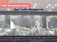
the Road Traffic Management System was established and is being operated to maximize the efficiency of road utilization.
도로교통관리시스템은 도로의 이용효율을 극대화하기 위해 도로교통관리시스템을 구축 운영합니다.
Seoul TOPIS’s high-tech Road Traffic Management System not only collects traffic information utilizing detectors and taxi GPS, but also analyzes the causes of traffic jams by analyzing chronic congestion and congested areas to ease chronic congestion by adjusting signal operation schedules and change road geometries.
서울 TOPIS의 첨단도로교통관리스템은 검지기 및 택시 GPS를 활용한 교통정보수집 뿐만 아니라, 상습정체 및 혼잡지역 분석을 통해 정체 원인을 분석하여 신호 운영시간 재조정 및 도로기하구조 변경을 통해 상습정체가 해소되도록 지원합니다.
Also, the system promptly detects unexpected situations, such as accidents, by closely monitoring traffic situations and provides citizens with detour route information to minimize traffic jams.
또한 빈틈없고, 촘촘한 교통상황감시를 통해 사고 등 돌발상황을 신속히 감지하고, 시민들에게 우회정보를 신속히 전달함으로써 시민들이 겪는 교통정체가 최소화되도록 지원하고 있습니다.
The Bus Information System secures the punctuality of vehicle operations and enables the management of bus operation and collects, processes, and analyzes bus location information in real-time to provide a variety of information on buses.
다음으로 버스정보시스템은 차량 운행 정시성 확보와 버스 운행관리가 가능하게 하고, 실시간 버스위치 정보를 수집, 가공 분석하여 다양한 버스정보를 제공하고 있습니다.
The system also evaluates transportation companies by analyzing bus operation information and passenger travel information, optimizes the bus route and selects the bus stop location, creates a pleasant bus environment, enhances transportation convenience, and prevents various accidents through the Bus Congestion Information Service provided in the vehicle.
또한 버스 운행 정보, 승객 승하차 정보의 분석을 통해 운수사 평가, 버스 노선 최적화 및 정류소 위치를 선정하고, 차내 버스혼잡도 안내서비스 등을 실시하여 버스의 쾌적한 환경 조성 및 시민 교통편의 증진, 각종 안전사고 예방에도 크게 기여하고 있습니다.
TOPIS’s Unmanned Regulation System/Automatic Fine Imposition System introduces and operates a total of 336 unmanned regulation system to crack down on vehicles violating exclusive lane regulations.
토피스의 무인 단속 및 과태료 부과 시스템은 대중교통전용도로 위반 차량을 단속하기 위해 총336대의 무인단속 시스템을 도입·운영하고 있습니다.
The system regulates vehicles parked in no parking areas or no stopping areas for more than 5 minutes and those violating various exclusive lane regulations.
무인단속시스템을 통해서 주정차 금지구역에서 5분 이상 차량을 주정차하는 불법 주정차차량, 각종 전용차로를 운행하는 위반 차량을 단속합니다.
The Traffic Forecasting System establishes and operates a traffic forecasting system through statistical technologies that analyze unexpected information such as weather and accidents as well as traffic volume and speed.
교통예보시스템은 기상, 사고 등 돌발정보, 교통량 및 속도 등의 통계적 분석 기술을 통해 교통예보 체계를 구축, 운영합니다.
Also, it alerts citizens about congested areas and hours in advance through traffic forecasts so that they can use the roads without being stuck in traffic.
그리고 교통예보를 통해 시민들이 사전에 혼잡구간과 혼잡시간대를 피해 도로를 이용할 수 있도록 지원합니다.
TOPIS plans to extend the Traffic Forecasting System to major roads in Seoul.
토피스는 도시고속도로 교통예보에 이어 서울시 주요도로까지 교통예보시스템을 확대할 것입니다.
In Seoul, a large amount of transportation card data is accumulated as citizens use their transportation cards.
서울시는 시민들이 교통카드를 사용하면서 방대한 양의 교통카드데이터가 축적되고 있는데요.
Along with other big data such as public transportation driving information, the accumulated data is used to analyze citizens’ patterns of use of public transportation and to monitor and improve public transportation policies by installing transfer facilities and adjusting bus routes.
축적된 교통카드 데이터는 대중교통 운행정보 등 다른 빅데이터와 연계되어 시민들의 대중교통 이용행태를 분석하는데 활용되며, 환승시설 설치, 버스 노선 조정 등 대중교통 정책의 모니터링 및 개선에 활용되고 있습니다.
Now, we are going to talk about Seoul TOPIS’s Outdated Automobile Restriction System in the Green Transport Zone.
이번에는 서울 토피스의 녹색교통진흥지역 자동차통행관리시스템에 대해 알아보겠습니다.
Seoul’s Automobile Restriction System in the Green Transport Zone refers to the Seoul Metropolitan Government’s particulate matter reduction measure in terms of transportation which took effect starting in December 2019. The system aims to reduce particulate matter and traffic congestion by prohibiting outdated grade-5 automobiles, which are the main cause of particulate matter, from driving in downtown Seoul.
이와 관련된 서울 녹색교통지역 운행제한제도는 미세먼지 주요 배출원인 5등급 노후 자동차의 도심지역 운행 제한을 통해 미세먼지 문제와 도심 교통난을 해결하고자 2019년 12월부터 시행한 서울시의 교통수송 분야 핵심 미세먼지 저감 대책을 말합니다.
The Green Transport Zone’s traffic volume control system monitors and controls all traffic volume of the Green Transportation Zone, a limited area within Hanyangdoseong, in real-time and automatically detects and imposes fines on grade-5 automobiles that violate the driving restriction rules.
녹색교통진흥지역 차량통행관리시스템을 통해 한양도성으로 한정한 녹색교통지역의 자동차통행량 총량관리 및 실시간 모니터링을 하고 친환경5등급 운행제한 위반차량에 대한 자동단속 및 과태료를 부과합니다.
Also, outdated automobile restriction systems installed at the 45 entry points along the boundary roads of the Green Transport Zone detect grade 5 vehicles from 6:00 a.m. to 9:00 p.m., 7 days a week, even on weekends and holidays.
또한 녹색교통지역 경계도로인 45개 진입 지점에 설치된 자동차통행관리시스템을 활용해 토, 일, 공휴일을 포함해 06~21시까지 상시 단속하고 있습니다.
Next, let’s talk about the Seoul C-ITS demonstration project.
지금부터는 서울 C-ITS 실증사업에 대해 알아보겠습니다.
It refers to a system that provides drivers with accident risk information in real-time, such as pedestrian location, peripheral traffic conditions, sudden stops, and fallen objects via vehicle to vehicle (V2V), vehicle to infra (V2I), and vehicle to pedestrian (V2P) communications.
이 시스템은 차량간 통신(V2V), 차량과 인프라간 통신(V2I), 차량과 사람(V2P) 등을 통해 운전자에게 보행자 위치, 주변 교통상황 및 급정거, 낙하물 등의 사고 위험 정보 등 실시간으로 제공하는 시스템입니다.
Let’s talk about this a little more in detail.
관련 내용을 조금 더 구체적으로 알아볼까요?
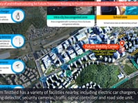
The Seoul Metropolitan Government established the world’s first 5G-based automated driving testbed in Sangam DMC. Since its opening, the autonomous shared bus has been in service.
서울시는 상암 DMC를 대상으로 세계 최초 5G 융합 자율주행 테스트베드 확대 조성으로 자율주행 셔틀버스를 정기 운행했습니다.
The Seoul Metropolitan Government supported the demonstration of mobility, such as car sharing and automatic parking, in the Sangam-dong automated driving testbed.
그리고 상암동 자율주행 테스트베드 내 공유차량, 자율주차 등 모빌리티 실증을 지원했습니다.
In the case of the automated car sharing service, when an automobile is called, it automatically drives to the passenger. When he/she gets into the car, it automatically drives to the destination.
그리고 자율주차의 경우 승객이 하차하면 빈 주차 공간을 검지하고 자율주행을 해서 자율주차를 합니다. 완료가 되면 위치를 송부합니다.
In case of automatic parking, when the passenger gets out of the car, the automobile detects an empty parking space and automatically parks itself. When the process is complete, the automobile sends its location.
자율주행차량 공유서비스의 경우 모바일 차량을 호출하면 자율주행을 해서 승객에게 오고 승객이 승차 후 다시 자율주행을 해서 목적지까지 갑니다.
Also, the Seoul Metropolitan Government formed the automated driving cooperation with global companies including Hyundai Motors, LG Electronics, and Samsung Electronics. The SM established the Sangam Automated Driving Innovation Cluster to become the number 1 in the automated driving industry.
또한 현대차와 LG전자, 삼성전자 등 글로벌 기업과 함께 자율주행 협력체를 구성하였으며, 자율주행 산업화 1번지가 되기 위해 상암 자율주행 혁신 클러스터 조성에 앞장섰습니다.
The route of the 2020 Testbed is Digital Media City Station – Event Venue (Nurim Square) – Digital Media City Station.
2020년 테스트베드의 경로는 디지털미디어시티역~행사장(누림스퀘어)~디지털미디어시티역입니다.
The feature of the 2020 Sangam Testbed is that it is an automated driving testbed where everything is connected through 5G and WAVE.
그리고 2020년 상암테스트베드의 특징 모든 것이 5G와 WAVE로 연결되는 자율주행 테스트베드라는 점입니다.
It can connect vehicle to pedestrian, vehicle to vehicle, vehicle to infrastructure, vehicle to entertainment, vehicle to network, vehicle to road work, and vehicle to bicycle. Also, it connects vehicle to control center.
또한 차량과 사람, 차량과 차량, 차량과 인프라, 차량과 엔터테인먼트, 차량과 네트워크, 차량과 공사, 차량과 자전거와 연결이 가능합니다. 또한 차량과 관제센터를 연결합니다.
V2C, which connects vehicles and the control center, is an automated vehicle control tower. Overseas buyers and relevant organizations visit V2C to see advanced technology and learn excellent cases.
또한 차량과 관제센터를 연결하는 V2C는 자율주행차 운행 관제공간으로 해외바이어 및 관계기관들의 기술을 소개하고 우수사례를 참고하는 견학공간입니다.
There is also Detailed 3D Map. The maps include maps for automated vehicles, lanes, traffic signals and traffic signs. The maps enhance automated driving safety by measuring the accurate position of a vehicle.
또한 3D정밀지도가 있습니다. 3D 정밀지도는 자율주행차용 지도, 차선과 신호등, 표지판 정보를 포함한 것이며 차량의 정확한 위치 측정을 통한 자율주행 안전성을 강화합니다.
With global companies such as Samsung Electronics, we also have developed the world’s first all-in-one 5G connected car terminal that integrates bus operation management, transportation cards, vehicle-to-vehicle communication (V2X), and advanced driver assistance system (ADAS).
또한 삼성전자 등 글로벌 기업과 함께 세계 최초 5G, 버스운행관리교통카드, 차량간 통신(V2X), 교통안전센서(ADAS)가 통합된 올인원 단말기를 개발하였습니다.
The C-ITS demonstration project went through the test road (K-City), which is an early developed technology, and advanced, demonstrating mobility services in 2020. It combines the general road with various traffic situations using next-generation technologies such as 5G.
그리고 C-ITS 실증사업은 초기기술개발인 실험도로(K-City)를 거쳐 20년엔 고도화 및 모빌리티 서비스 실증을 하고 있으며, 다양한 교통이 혼재된 일반도로에 5G등 차세대 기술을 융합하여 보여주고 있습니다.
When passing the stage, this can be commercialized as an automated driving innovation cluster (Sangam).
이 단계를 넘어서면 자율주행 혁신 클러스터(상암)로 상용화가 가능할 것입니다.
Development Direction of TOPIS
TOPIS의 발전방향
TOPIS is trying to preemptively respond to changes in transportation related to the 4th Industrial Revolution such as automated driving. In addition, it is putting forth the efforts to preoccupy future transportation and create infrastructure.
토피스는 자율주행 등 4차 산업혁명 관련한 교통변화의 선제적 대응 및 미래교통의 선점과 기반을 조성하기 위해 노력하고 있습니다.
TOPIS aims to create a bright future for citizens by strengthening industrial competitiveness through the preoccupation of future transportation markets such as cutting-edge IT, automobiles, and cooperative automated driving which fuses SOC technologies.
첨단 IT와 자동차, 그리고 SOC기술이 융합하는 자율협력 주행 등 미래교통시장을 선점으로 산업 경쟁력을 강화하여 시민들이 살기 좋은 미래가 되도록 하고자 합니다.
In order to become the world's city in the automated driving industry by 2025, the Seoul Metropolitan Government will establish a foundation for the demonstration of automated driving, such as the automated driving testbed, and innovate traffic safety based on the world’s first 5G-based connected cars.
2025년 자율주행 산업 경쟁력 세계 1등 도시로 도약을 위해 자율주행 테스트베드 등 자율주행 실증 기반을 조성과 세계 최초로 5G기반 커넥티드카 기반으로 교통안전 등을 획기적으로 혁신하고자 합니다.
By creating the high-tech road infrastructure such as blind spot surveillance, Seoul also opens traffic signals especially for roads with exclusive median bus lanes which are at high risk of traffic accidents and reduces traffic accidents by over 30% with connected traffic safety services.
또한 미래교통기반 첨단도로 인프라 조성으로 교통사고 위험이 높은 중앙버스전용차로 운영도로를 중심으로 교통신호를 개방하며, 사각지대 보행자 감시 등 첨단 도로인프라 조성으로 커넥티드 교통안전서비스 시행으로 교통사고를 30% 이상 감소할 수 있습니다.
Exclusive median bus lanes in Gangnam-daero, Yanghwa/Sinchon-ro, Jong-ro, etc. are subject to the project, and the size of the project is 121.4 km.
대상은 강남대로, 양화신촌로, 종로 등 중앙버스 전용차로이고, 규모는 121.4km입니다.
The project includes a total of 1,083 units of C-ITS infrastructure installation, including traffic signals and blind spot surveillance. In addition, the project supports 1,700 vehicles, mainly buses, with a 5G-connected car terminal and traffic safety.
주요 내용으로는 교통신호와 사각지대 감시 등 총 1,083식 C-ITS인프라를 구축하며, 버스 중심 5G커넥티드 카 단말장착 1,700대 및 교통안전을 지원합니다.
Now, we are going to talk about “MyData” app.
지금부터는 ‘마이데이터’앱에 대해 알아보겠습니다.
Starting in December 2020, TOPIS has been providing citizens with the “MyData” service that recommends a customized service by analyzing individual behavioral characteristics based on AI.
토피스는 인공지능(AI) 기반으로 개인의 통행특성을 분석해 맞춤형 서비스를 추천하는 ‘마이데이터’ 서비스를 2020년 12월부터 ‘마이데이터 앱’을 통해 시민들에게 제공하고 있습니다.
Once you agree to the provision of personal information, AI analyzes your travel data scattered through numerous organizations and companies, such as public and shared transportation including bicycles and scooters paid for with a credit card. Then, it finds a customized route in real-time.
개인정보 제공에 동의하면 신용카드를 이용한 대중교통 탑승, 자전거나 킥보드 등 공유 교통수단 이용 같이 여러 기관과 기업에 흩어져 있는 자신의 통행‧이동 궤적 데이터를 통해 AI가 실시간 맞춤경로를 찾아냅니다.
It is also expected to greatly reduce travel time and costs by considering information predicted in real time such as traffic, travel, and weather.
그리고 실시간으로 예측되는 교통, 통행, 날씨 등의 정보도 반영하여 이동시간과 비용을 대폭 줄일 수 있을 것으로 기대됩니다.
The distribution of demand will be induced by providing information on congestion risk areas, such unexpected assemblies, to change hours and means of use.
돌발집회 등 혼잡위험지역 안내서비스, 대중교통 혼잡도 등도 안내해 이용시간 및 이용수단 변경을 통한 수요 분산을 유도할 예정입니다.
For the safe use of public transportation, especially in the era of a pandemic, MyData offers services that compare and analyze the travel routes of confirmed COVID-19 patients with yours. It swiftly informs you whether your travel route overlaps with any of the patients through a follow-up notice.
특히, 감염병과 공존이 불가피한 시대에 더 안심하고 대중교통을 이용할 수 있도록 코로나19 확진자 이동동선 데이터와 비교‧분석을 통해 내 이동 경로와 겹칠 경우 사후 안내를 통해 신속하게 확인 할 수 있게 됩니다.
The Seoul Metropolitan Government establishes a big data integrated platform that can freely analyze data anytime and anywhere.
서울시는 언제 어디서나 자유롭게 분석할 수 있는 빅데이터 통합 플랫폼을 구축합니다.
The Seoul Metropolitan Government expands real-time data collection, collection automation, and linkage to external organizations and promotes integrated management of basis information and expanded storage space (linked to integrated storage), establishment of convergence analysis system for real-time big data, standard establishment for data convergence and creation of an application system, provision of information, unification of sharing platform, and promotion of quality control.
실시간 데이터 수집과 수집자동화 및 외부 연계기관을 확대하며 기반정보 통합관리 및 저장공간 확대(통합저장소 연계), 실시간 대용량 데이터의 융복합 분석 체계 구축, 데이터 융복합을 위한 표준구축 및 활용체계 마련, 정보의 제공과 공유 창구 일원화 및 품질관리를 추진합니다.
This will allow big data to be used as a base in clear and responsible decision-making through specific and detailed creation and management of statistics.
그리고 구체적이고 상세한 통계 작성과 관리로 보다 명료하고 책임 있는 의사결정의 근간으로 활용될 것입니다.
Decisions and policies are made based on the results of big data analysis.
그리고 빅데이터 분석 결과에 기반한 의사결정과 정책을 시행하게 되는데요.
Support for the convergence and activation of big data in the public and private sectors can discover new services and create future jobs.
공공과 민간 빅데이터 융합과 활성화 지원으로 새로운 서비스 발굴 및 미래형 일자리를 창출할 수 있습니다.
So, what are the future strategic technologies to which TOPIS pays attention?
그렇다면, 토피스가 주목할 미래전략 기술은 어떤 것이 있을까요?
Future strategic technologies to which TOPIS pays attention include IoT, autonomous vehicles, connected vehicles, big data, electric vehicles and other eco-friendly vehicles, fintech, sharing economy that will become even more activated in the future, MaaS, and MyData.
토피스가 주목하고 있는 미래 전략 기술들에는 IoT, Autonomous Vehicle, Connected Vehicle, 빅데이터, 전기차와 각종 친환경차량, 핀테크, 현재에도 진행되고 있으나 더 활성화될 공유경제, MaaS, 마이데이터 등이 있습니다.
Going forward, TOPIS will focus on informatizing big data, expanding safety features and information on eco-friendly vehicles.
앞으로 토피스는 빅데이터를 정보화하는데 주력하며 안전기능을 확대하고 친환경 차량정보 등을 확장할 것입니다.
TOPIS will also focus on analysis of variability and future predictions to consider utilizing multi-tool information.
그리고 변동성을 분석하고 미래를 예측하는데 주력하며 다수단 정보를 활용하는 걸 고려할 것입니다.
MyData resolves the traffic issues of the city and lets anyone use its data freely. It will develop future strategic technologies so that citizens can use public transportation more safely and conveniently.
또한 도시의 교통 문제를 해결하고 누구나 자유롭게 데이터를 이용하며 시민들이 좀더 안전하고 편리한 대중교통을 이용할 수 있도록 미래전략기술을 발전시켜 나갈 예정입니다.
We will put forth the efforts to establish eco-friendly smart mobility that align with the times. In addition, we will fully cooperate so that other countries can utilize Seoul TOPIS’s future technologies as well.
그리고 뉴노멀시대에 맞는 친환경 스마트모빌리티 구축을 위한 노력과 세계의 다른 나라들이 서울의 토피스 미래 기술을 활용할 수 있도록 적극 협력하겠습니다.