Urban Planning System of Seoul
Structure
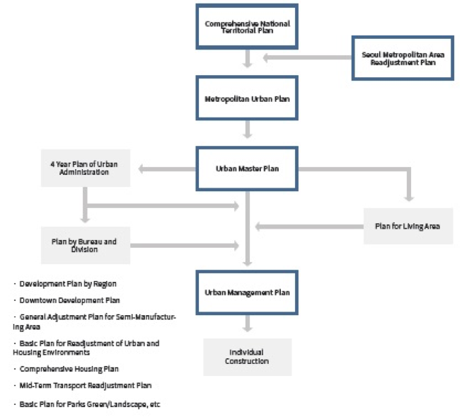
As a sub-plan of the urban master plan and the living area plan, the urban management plan is an implementation plan that aims to materialize and realize the long-term urban development direction suggested in the upper level plans in the relevant spaces. The urban management plan includes a land use zoning plan, an urban planning facility project plan, individual district unit plans, an urban development project plan, and various kinds of readjustment projects, etc. Each project plan is established and operated individually. The SMG is seeking ways to strengthen the functions of the urban management plan to operate it efficiently, and is preparing the integrated implementation of the current urban management plan.
In order to improve the establishment and operation of the urban planning system as well as accommodate the characteristics and changes of Seoul, the SMG has strived to prepare concrete and detailed plans through professional monitoring and an expanded citizen participation, and establish Seoul’s constant urban planning system.
Stage 1. Urban Master Plan
Definition
Purposes and Background of Planning
The urban master plan was established to promote the rational use, sustainable development and preservation of affordable land. It is a comprehensive plan that presents a framework for the developed city after a period of twenty years. The urban master plan suggests the direction of policies for using limited resources efficiently and reasonably, improving the quality of life of Seoul’s inhabitants, and achieving environmentally sound and sustainable development.The urban master plan is a comprehensive plan that encompasses diverse aspects of the entire city including society, economy, environment, energy, transportation, infrastructure, culture, and welfare. Therefore, it is necessary to collect the diverse and extensive opinions of citizens, experts, administrators, and others, and to adjust the plan in the planning process by securing procedural justification.
The urban master plan of Seoul was established by law for the first time in 1990 according to the amendment of the “Urban Planning Act” enacted in 1981. Thereafter, legal planning was conducted on four occasions, including adjustments made in 1997 (target year: 2000), 2006 (target year: 2020) and 2014 (target year: 2030). The “2030 Seoul Plan” is the fourth statutory plan formally established at the SMG-level. As the plan has the highest status in the planning system of Seoul, it serves as a guide on the directions of the relevant sub-plans, such as the urban management plan, and ensures that they are established in a consistent and unified manner.
The 2030 Seoul Master Plan (Seoul Plan) was made by reorganizing the previous content and formats according to the sign of the times in order to readjust the Seoul urban master plan in 2020. The right to set the urban master plan was transferred to the local government, thereby increasing the Seoul Mayor’s autonomy. This is because there is a pressing demand to realize new social values such as civil participation and a sharing society.
Scope of the Plan
Temporal Scope: The target year of the urban master plan was set 20 years into the future from the time of planning, according to the guideline for the establishment of the plan. The status of each sector—such as population, industry, economy, environment, transportation, housing, etc.—is documented as of the beginning year. Based on the investigated status, the goals and strategies for each sector were established and the planning indicators set.
Spatial Scope: The spatial scope of the plan is the entire urban planning area matching Seoul’s administrative districts, with a total area of 605.96 km2. However, the target areas were expanded to the Seoul metropolitan areas in the vicinity of Seoul when analyzing the status and conditions in order to decide the planning tasks and plan the spatial structure reorganization.
Status and Roles
1. The highest legal plan encompassing all areas of Seoul
2. Long-term plan to present the future image 20 years hence and development directions
3. Spatial plan to reflect the future image and core issues in spatial structure and land utilization
4. Strategic plan that emphasizes the efficiency of resources by establishing policy priorities
Contents of the Plan
The plans regarding the core issues were designed to set administrative priorities while combining the entire administrative fields of Seoul and securing the consistency of the plans. They constitute the theme plan for Seoul. The specific theme-centric plans were reconstituted by considering the characteristics of Seoul based on the guidelines for the establishment of the urban master plan.
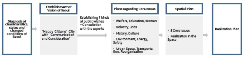
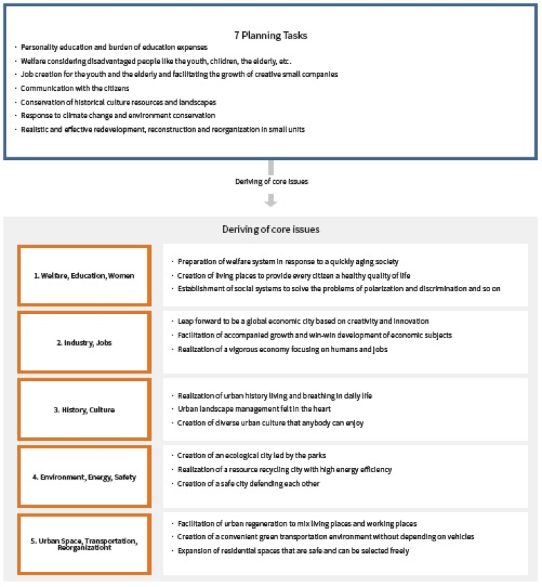
To facilitate the establishment of the 2030 Seoul Plan, the SMG formed a civil participation group to discuss the tasks to be solved issues that the SMG should address and selected planning tasks in seven areas: education, welfare, jobs, communication, historical culture & landscape, climate change & environment, and urban development & reorganization. These seven planning tasks formed the foundation of the divisions in the following five areas: (a) welfare/education/women, (b) industry/jobs, (c) history/culture, (d) environment/energy/safety, and (e) urban space/transportation/reorganization. There were then positively reflected in the process of establishing the goals and strategies of the plans regarding the core issues.
In addition, the SMG presented the regional conception of the living area plan while considering the regional characteristics in order to materialize the basic contents of the plan and facilitate balanced regional development. In order to accomplish the goals of the plans, the urban planning system of Seoul, a constant monitoring system, establishment of the civil participation and governance system, and the principles and directions of financial investment were included in the plan.
In the 2030 Seoul Plan, the spatial structure of Seoul was planned to be transferred to the structure of multi-centers by setting it to be ‘three city centers, seven metropolitan centers, and twelve regional centers.’ This multi-centered structure was designed to facilitate a win-win development through cultivation of special contents by the centers and functional links between the centers. The SMG manages all of these city, metropolitan, and regional centers strategically from the perspectives of the metropolitan region of Seoul and the five macro living areas.
Spatial Structure
The existing single-centered system consisting of “one city center, five sub-city centers and eleven regional centers” in a simple hierarchy had limits in resolving the issues raised at the upper levels. With the 2030 Seoul Plan, Seoul reorganized the single-centered system into “three city centers, seven metropolitan centers and twelve regional centers” to emphasize the functional system of multiple centers and to facilitate a win-win development through the cultivation of special contents by the centers and functional links between the centers.
The single-centered system was the basic element in forming the spatial structure of Seoul. The special structure was formed by designating the centers that the SMG had to manage directly. In other words, the SMG decided to provide a strategic management service to those city, metropolitan, and regional centers that played core roles in the Seoul metropolitan areas and the five regional living areas. The centers of the districts as the basis for daily life in each regional living area in the existing 2020 urban master plan were maintained, but they were allowed to be adjusted through consultation with the autonomous districts if necessary when establishing the living area plan as the follow-up to the urban master plan. In other words, the designation and management of the district centers could be negotiated and adjusted in consideration of the demands of the autonomous districts and their residents.
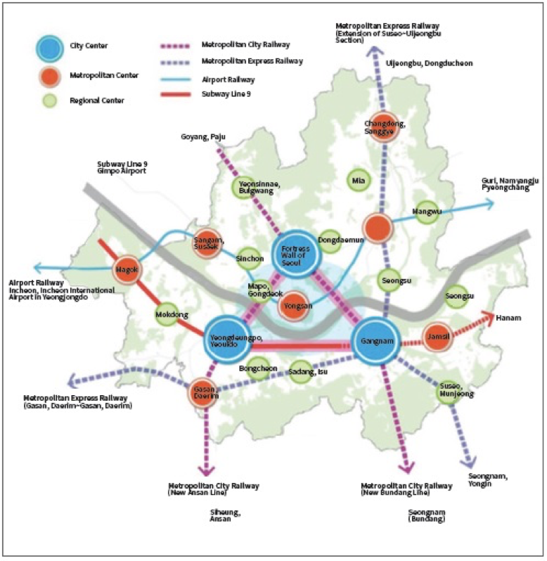
○ City Centers: Strengthening of global competitiveness
○ Metropolitan Centers: Facilitation of regionally balanced development by fostering functionally specialized centers
○ Regional Centers: Preparation of employment basis by living area and strengthening of self-sufficiency
Establishment Procedure
The “Committee to Promote the Establishment of the 2030 Seoul Plan” drew up a draft urban master plan, including plans regarding the core issues, plans for spatial structure, land use, regional designs and methods, in order to realize the plans through a survey, a collection of opinions from each district, and an advisory conference by field. The draft was modified and supplemented to reflect the opinions of the related divisions of the SMG and the appropriate opinions of the citizens obtained at briefing sessions and public hearings in the districts. The urban master plan established by the citizens, experts and administrators together was finally confirmed after passing through the relevant legal administrative procedures, including deliberation by the urban planning committee. The feasibility of the urban master plan has to be reviewed and adjusted every five years by the special city mayor, the metropolitan city mayor, the special autonomous municipal mayor, and the governors or heads of counties.

Stage 2. Living Area Plan
Definition
In the 2030 Seoul Urban Master Plan (Seoul Plan), the “living area” is set as the necessary range of activities required for full engagement in day-to-day life, and is defined as the spatial range encompassing commuting to work or school, shopping, leisure activities, and social activities. At present, the living area plan is not a statutory one. For the continuous establishment and operation of the living area plan, it will be necessary to legalize the plan according to the “National Land Planning and Utilization Act.”
Purposes of and Background to Establishment of the Plan
The living area plan is the intermediate stage of the planning system established at the level of Seoul’s regions and living areas. It is established not only to materialize the vision of Seoul and the long-term development directions regarding regional issues, but also to serve as a guide for the consistent and unified establishment of the urban management plan, the sub-plan of the urban master plan. The background to the living area plan is as follows.
○ Intermediate level of plan to improve realization of the urban master plan
- Seoul, with its 10 million inhabitants, is not only the capital city of the Republic of Korea but also the center of a metropolitan economic bloc with a huge population of 25 million. Like many small- and medium-sized cities, Seoul used to be operated according to a two-layer plan consisting of an urban master plan and an urban management plan until relatively recently. But there were limits in connecting and realizing the long-term development directions presented in the urban master plan with the urban management plan in a large metropolitan city like Seoul. Therefore, the need for a living area plan emerged as an intermediate step to link the two plans, thereby improving the effectiveness of the urban plans. Based on the scheme, dual planning is now conducted for the five regions (large living areas) and the sub-divided zones (small living areas).
○ Establishment of area plans based on the lives of citizens
- City development and management in the past were led by large-scale development and demolition, such as large-scale housing land development, reconstruction, and new town projects. Areas outside the plan suffered from continuing decline and the small units of plans were no longer a priority. In other words, the existing urban plans of Seoul had limits in systematically solving the inconveniences felt by citizens in their daily lives. In order to address such problems, the SMG initiated the living area plan, which was closer to the citizens’ daily life, in order to establish a regional vision and development directions together with the citizens and to implement various urban plans.
○ Bottom-up plan established with the participation of residents of the regions.
- Most of the urban plans of Seoul were made using a top-down system established and operated mainly by officials and experts. The top-down plans had the advantage of managing all of the city in a comprehensive and consistent manner, but had limits in reflecting the regional characteristics and the diverse demands of residents. The “living area plan” was designed to switch the existing planning system to a bottom-up system, as in the 2030 Seoul Plan, and to actively support resident participation. With this plan, procedural measures for seeking solutions aimed at improving long-overdue regional issues and living conditions together with the SMG and local governments were prepared, making to possible to secure the requisite justification and procedural rationality.
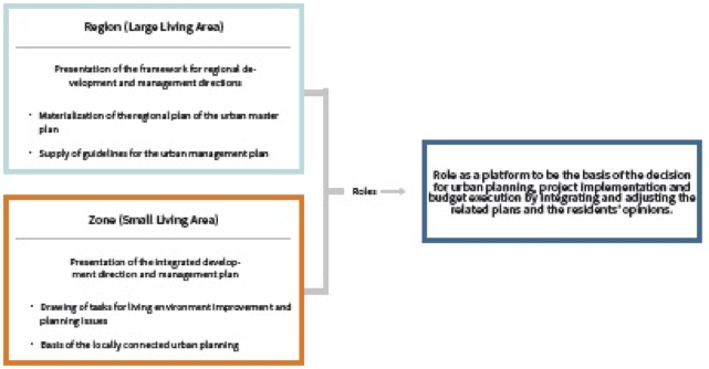
○ The living area plan’s role as a “mediator” in integrating and coordinating the related plans by sector (bureau and division)
- The SMG established and operated plans by sector (bureau and division), such as housing, transportation, parks and green areas, landscape and industry, in addition to the urban master plan. But the plans by sector (bureau and division) were found to be at odds with each other because they were established at different times. Thus, the living area plan plays an important role as a mediator when integrating and adjusting the plans by sector (bureau and division).
Scope of the Plan
Temporal Scope: The living area plan is the follow-up to the urban master plan. Its regional (large living areas) plan targets the next twenty years, like the urban master plan, while its area (small areas) plan targets the next ten years, as with the urban management plan. The first stage of the living area plan was established for the period from 2013-15 for four regions (northeast, northwest, southwest, and southeast) and one zone (small living area) of the autonomous districts in order to serve as an example. The second stage of the living area plan covered the period from 2015-16 for the downtown regions and the other zones (small living area), and entailed the implementation of the necessary administrative procedures.
Spatial Scope: The spatial scope of the living area was divided according to the urban scale, administrative economy, single-centered system, main terrains, and the purpose and nature of the activities and service zones by facility. In general, large cities are divided into three types of areas: small living areas, mid-sized living areas, and large living areas. In the case of Seoul, the living areas are divided into the two categories of “regional areas” (large living area) and “zones” (small living areas). Currently, there are five regional areas (large living areas) and around 140 zones (small living areas).
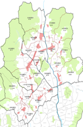
| <Figure 6> Division according to the five Regional Living Areas | <Figure 7> Northeast Regional Area |
.png) |
 |
| Classification | Regional Living Area | Living Zone |
| Concept | Regions including city center, sub-centers and adjacent areas | Regions including district centers, main station influence areas, and adjacent residential areas |
| Criteria | Hangang (River) and mountainous area running from north to south | Consideration of topography, large constructions and population |
| Intention Point | Spatial structure towards job-housing proximity in the regions Balanced development based on self-sufficiency |
Suggestion of regional development direction Establishment of tasks to improve residents/zone contacted living environment |
| Spatial Category | Five Regional Areas (When necessary, they can be supplemented by mid-sized living areas) |
Around 140 Zones (around three administrative sections with fewer than 100,000 inhabitants) |
Status and Roles
1. Established as a follow-up plan to the urban master plan
With the establishment of a planning system consisting of the urban master plan, living area plan and urban management plan, Seoul was equipped with a systematic planning framework containing plans not only at the level of the metropolitan city but also for the regional living zones for daily life.
2. Basis for decisions on urban plans, project implementation and budget execution
Contents of the Plan
The living area plan is a spatial plan that aims to materialize the urban master plan. It consists of five sections including centers & industry, dwelling areas, transportation, infrastructure, and regional specialization. Each of these sectors can be added, omitted or integrated according to the characteristics of the living area.
The five sections of the living area plan consist of the following:
1) The center & industry section produces and presents the developmental directions of the centers taking the roles of main business and commerce areas, and the main railway station areas, and the development methods and directions of the industrial resources needed to lead economic growth and to create jobs;
2) the dwelling areas section proposes readjustment, preservation and management directions according to the dwelling types and features;
3) the transportation section suggests improvement directions for public transportation and transportation infrastructure at the regional and zone levels;
4) the infrastructure for living section proposes methods of supplying infrastructure for living purposes and improving its utilization; and
5) the regional specialization section proposes how to develop and manage nature, history and culture to strengthen the local identity and features.
<Figure 9> Details of the Living Area Plan

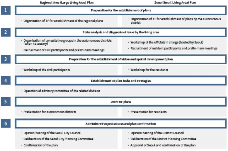
Establishment Procedure
The living area plan is established through six steps ranging from preparation for planning to administrative procedures and plan confirmation. It is focused on the following establishment process: the SMG – autonomous districts – residents and experts. Thus, it is important to create conditions that attract the proactive participation of the various subjects at each stage.
In particular, the citizen/resident participation group is organized in Step 2. This group diagnoses the issues and problems associated with changes in the living areas and then facilitates the regional vision and spatial development plan. For issues that can be solved in cooperation with neighboring districts, the SMG helps the task force team in each living area to collaborate in preparing the necessary reaction plans. And, when necessary, district consultative groups in the region can be organized.
Lastly, the living area plan has to pass through the same administrative procedure as the urban master plan, an upper level one, in order to be confirmed. The regional area (large living area) plan is confirmed via a hearing of the opinions by the Seoul City Council and the deliberation of the Seoul City Planning Committee. The zone (small living area) plan is confirmed through a hearing of the opinions of the District Councils, the deliberation of the District City Planning Committee, and the approval of the SMG.
<Figure 10> Establishment Procedure of the Living Area Plan
Stage 3. Urban Management Plan
Definition
-Plans for designation of or changes to limited development zones, urban nature park zones, controlled urbanization zones and fishery resource protection zones;
-Plans for the installation, reorganization or improvement of infrastructure;
-Plans for urban development or reorganization projects;
-Plans for designation of or changes to the district unit planning areas and the district unit plans.
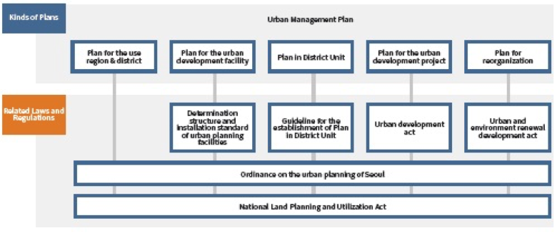
The urban management plan, designed to materialize and realize the long-term urban development directions presented in the urban master plan in specific spaces, is individually established according to the purposes of the plans in these areas, including the plans for use region, districts & areas, urban planning facilities, district unit plans, urban development projects, and reorganization plans.
Purposes of and Background to Establishment of the Plan
The purposes of the establishment of the 2020 Seoul urban management plan are to meet the necessity of the administrative procedure according to the regulation in the National Land Planning and Utilization Act, to review and renew the entire existing urban management plan every 5 years, and to present ways of realizing the plan after the renewal of the 2030 Seoul Urban Master Plan.
The purposes of establishing the Seoul urban management plan are to lay the groundwork for the urban management plan of Seoul, to suggest concrete methods of realizing the established 2030 urban master plan of Seoul, and to prepare the management standard for the use districts by integrating the adjustment standards for the use districts, which had previously been operated individually. The urban management plan manages and regulates the use and development of land designated directly for the development, reorganization, and preservation of the city, and has legal binding force.
Contents of the Plan
1. Plan for designation of or change to the use region, district or area.
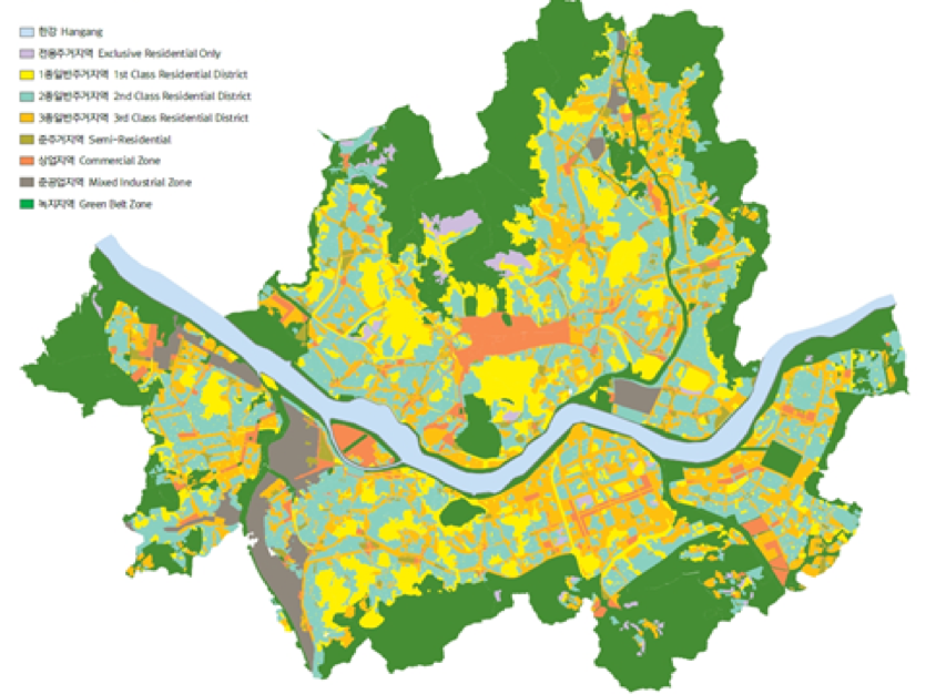
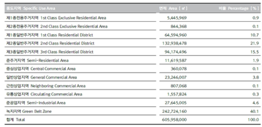
○ “Use Region” refers to land areas designated by the urban management plan to be used economically and efficiently, and without any overlapping, so as to facilitate the improvement of public welfare by limiting the use, building-to-land ratio, floor area ratio and height of construction projects. According to the National Land Planning and Utilization Act and the Ordinance on the Urban Planning of Seoul, the use region is divided into four use regions (urban, management, agriculture and forestry, and natural environment protection regions), and all parts of the land must be designated as one of them. As of 2013, the whole area of Seoul was classified into urban regions (605.96 km2), and then sub-divided into residential regions (51.6%), business regions (4.3%), industrial regions (4.5%) and green regions (39.6%).
○ “Use District” refers to areas selected under the urban management plan to increase the functionality of the use regions and to enhance their beauty, landscape and safety by strengthening or relaxing the limits—in terms of use, building-to-land ratio, floor area ratio, and height of constructions—in vigor in those regions. The use district was introduced as a means of effecting planned management and easy change of institution because there were difficulties in managing the city only with rough regulations on use regions. Use districts are divided into landscape, fine view, height, prevention, preservation, facility protection, community, and development promotion districts. As of 2013 some 197.80 km2 of land, or 33% of Seoul, was designated as use districts.
○ “Use Area” refers to areas selected by the urban management plan to prevent the disordered expansion of urban streets, to facilitate the planned and systematic use of land, and to perform the comprehensive adjustment and management of land use by strengthening or relaxing the limits on the use of land, building-to-land ratio, floor area ratio, and height of constructions in use regions and use districts. The use area acts as a means of controlling development activities or land uses in general through the execution of various kinds of regulated projects, unlike the use region or use district. It is divided into a limited development area, urban nature park area, urbanization control area, and fishery resources protection area. Limited development areas are designated by the urban management plan and when necessary to limit urban development, thereby preventing the disordered expansion of an urban area, protecting the natural environment, securing a sound living environment, and meeting the requests of national security. In the limited development area, all urban planning projects are prohibited, with the exception of activities or projects for which permission has been obtained on a case-by-case basis. Since 1972, the SMG had designated 166.82 km2 of land into limited development areas, but it has also lifted the restriction on 15.45 km2 for clustered settlement, national public housing, and Bogeumjari (nest) housing.
<Figure 12> Status of the Use Region of Seoul (As of 2012)
2. Plan for Installation, Renewal or Improvement of Urban Planning Facilities
○ According to Article 2 of the “National Land Planning and Utilization Act,” infrastructural facilities are divided into 52 types falling within 7 classifications, which the urban management plan designates as ‘urban planning facilities’ so as to maintain their urban functions.
| Classification | No. of Facilities | Type |
| Transportation Facilities | 10 | Roads, parking lots, railways, tracks, harbors, canals, airports, inspection facilities for vehicles and construction machinery, driving academies for vehicles and construction machinery, automobile stops. |
| Spatial Facilities | 5 | Plazas, parks, green areas, amusement parks, public open spaces. |
| Distribution & Supply Facilities | 9 | Water supply facilities, electric power supply facilities, gas supply facilities, oil storage and supply facilities, broadcasting & communication facilities, heat supply facilities, pipe utility conduits, markets, distributing facilities. |
| Public, Cultural and Physical Training Facilities | 10 | Schools, libraries, schoolyards, public offices, physical training facilities, cultural facilities, R&D facilities, social welfare facilities, youth training facilities, public vocational training facilities. |
| Disaster Prevention Facilities | 8 | Rivers, reservoirs, storage dams, fire prevention equipment, wind protection facilities, flood protection facilities, embankment facilities, erosion control facilities. |
| Sanitation Facilities | 7 | Cremation facilities, cemeteries, enshrined facilities, natural burial sites, funeral homes, slaughterhouses, general medical facilities. |
| Environmental Basic Facilities | 4 | Sewers, water pollution prevention facilities, waste treatment facilities, junkyards. |
3. Plan in District Unit
○ There are limits in solving the problems related to urban appearance and growth management using only the construction law, as it regulates use regions and districts in loose ways and proposes minimum construction standards because of the accelerated extensional growth and quantitative growth of Seoul since the 1970s. In order to address such problems, the SMG introduced the plan in district unit to allocate the functions and roles to cope with various urban problems. The plan in district unit has become established as an integrated and intensive urban management institution that considers the flat land use plan and the three-dimensional construction plan at the same time in the interest of harmony.
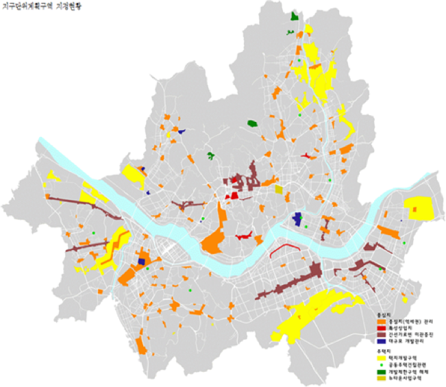
○ The districts that the SMG designates as areas for the plan in district unit are the areas for strategic development and planned renewal, such as areas requiring public facility renewal, street environment renewal, premeditated management of use, building-to-land ratio, floor area ratio and height, local specialization and activation by attracting cultural facilities and venture industries, areas of mixed land use for residential and industrial use in semi-industrial regions, areas with a dense concentration of low-rise housing, areas requiring financial support for balanced local development, and areas for the development of private capital stations.
4. Planning for Urban Development Projects
○ The main goals of urban development projects are to create a pleasant urban environment and to increase public welfare. They can be implemented only when decided and announced as an urban management plan according to the National Land Planning and Utilization Act. Such projects must be executed in compliance with the Urban Development Act.
○ In order to designate a section for urban development, the designator must establish plans for the development project in the relevant area. The name, location, area, designation purposes of the urban development section, project period, contractor, method of implementation, population accommodation plan, land use plan, traffic processing plan, environmental preservation plan and financing plan must all be included in the development plan.
5. Plan for Renewal Projects
○ Renewal projects can be implemented only when decided and announced as part of an urban management plan according to the National Land Planning and Utilization Act. Such projects must be executed in compliance with the Urban and Residential Environment Renewal Act.
○ The term “renewal project” refers to the renewal of infrastructure and the improvement or construction of buildings including houses in renewal sections or town street sections (which are not renewal sections but are designated by Presidential Decree).
○ In order to have an area designated as a renewal section, the head of a local government must establish the renewal plan, notify the residents of the plan in writing 30 days in advance for public inspection and opinion collection, and apply for designation as a renewal section to the SMG. The name of the renewal project, renewal section and area, urban planning facilities, joint use facilities, main use/building-to-land ratio/floor area ratio/height of the buildings, environment preservation and disaster prevention plans, educational environment protection plan, tenant housing measures and scheduled period of the renewal project should all be included in the renewal plan.
Implications
The urban planning system works in three stages, urban master plan – living area plan– urban management plan, as shown above. For better and more desirable operation of the urban planning system, however, the following improvements and complements are required.
Substantiality of the Planning System
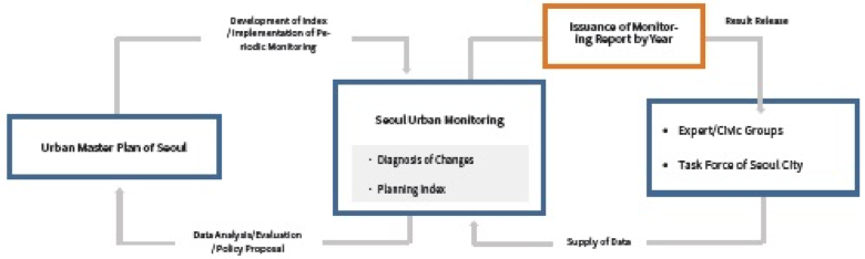
Establishment of Urban Plan Monitoring System
Civil Participation and Strengthened Communication System
References
Jae-seop Yang, Sang-il Kim, Jae-su Lee, Seon-woong Kim, et al., 2010, Direction of Establishment of Seoul Type of Urban Planning System for the Preemptive Urban Management, Seoul Development Institute
Korea Planners Association, 2009, Theory on Urban Planning, Boseonggak
The Seoul Metropolitan Government, 2014, Main Report on the “2030 Urban Master Plan of Seoul”, the Seoul Metropolitan Government
The Seoul Metropolitan Government, 2013, Establishment and Implementation of Living Area Plans of Seoul, the Seoul Metropolitan Government
The Seoul Metropolitan Government, 2012, Readjustment of Urban Management Plan of Seoul, the Seoul Metropolitan Government
The Seoul Metropolitan Government, 2010, Study on the Efficient Operating Methods of the Overlapped and Complexed Urban Planning Facilities, the Seoul Metropolitan Government
Seon-woong Kim, Jun-ho Gho and In-su Song, 2011, Reality Evaluation and Complementary Direction of Urban Management on the Limited Development Districts of Seoul, Seoul Development Institute
Hyeun-su Kim, 2014, “Issues and Tasks of Deregulation of the Limited Development Districts” in the Issue Report of the Seoul Institute, the Seoul Institute
Hui-ji Lim, et al., 2007, Urban Planning and Design of Seoul, the Seoul Institute