Changes to Seoul’s Administrative Districts and Development of Urban Space
Changes to the Administrative Districts and Urban Planning Zones
Location
Seoul, which is the capital of the Republic of Korea, is located at the heart of the Korean Peninsula. It is surrounded by Namyangju-si, Guri-si and Hanam-si to the east; Incheon Metropolitan City, Goyang-si, Gimpo-si and Bucheon-si to the west; Seongnam-si, Gwacheon-si, Anyang-si and Gwangmyeong-si to the south; and Uijeongbu-si and Yangju-si to the north. Seoul is located at 126°45′~127°11′ east longitude and 37°25′~37°41′ north latitude. Seoul is located approximately 50km east from Incheon International Airport, to which it is connected by the airport railways and various routes of airport buses to Seoul Station at approximately 1 hour’s distance.
<Figure 3> Geographic Location of Seoul
.png)
Geographic Features
Seoul is located in a basin surrounded by four outer mountains (Oesasan) and four inner mountains (Naesasan) and its major rivers include Hangang and its four branches as well as Cheonggyecheon.
To be more specific, the four outer mountains surrounding Seoul are Bukhansan (north), Deokyangsan (west), Gwanaksan (south) and Yongmabong (east). The four inner mountains located in the center of Gangbuk, where palaces from the Joseon Dynasty and main facilities of Hanseongbu used to be, are Naksan (east), Inwangsan (west), Namsan (south) and Bukaksan (north). Hangang River flows from the east to west through these mountains and its four branches; Tancheon, Jungnangcheon, Anyangcheon and Hongjecheon flow in various districts. Also, Cheonggyecheon River, flowing between Jongno-Gu and Jung-gu, flows into Hangang at Jungnangcheon.
With great natural features like these, Seoul has a wonderful natural environment. Its outer and inner mountains and main rivers have long been used as key elements of the urban planning of Seoul with a history of changes throughout the years.
| <Figure 1> 3D Terrain Map (2011) | <Figure 2> Terrain Map (2009) |
.png) |
.png) |
Climate
Seoul climate is between the warm climate of the southern area of Korea and the microthermal climate of the northern area and has four distinct seasons and sharp year-round air temperature and precipitation fluctuations. Compared to 1910, the current temperature and precipitation of Seoul has increased; the annual average temperature and precipitation rose from 10.3°C to 12.2°C and 1,021㎜ to 1,646㎜ respectively between 1910 and 2012.
<Figure 3> Annual Average Temperature and Precipitation (1910-2012)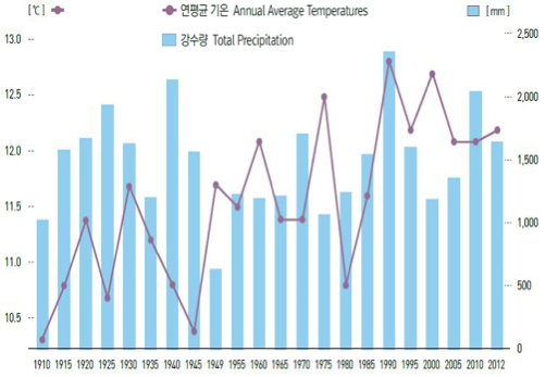 |
<Figure 4> Monthly Average Temperature and Precipitation (2012)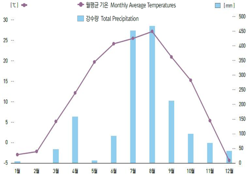 |
As of April 2012, Seoul’s average temperature by season is higher in developed areas than the suburbs. This type of temperature distribution indicates the city is still under the heat island effect, despite efforts to provide more parks and green areas in the city. This is closely related to the changes in soil covered area caused by the increase of high-rise buildings, road pavement and the decline of green zones.
<Figure 5> Seasonal Average Temperatures (2012)

Changes to the Administrative Districts and Urban Planning Zones
Changes to the Administrative Districts
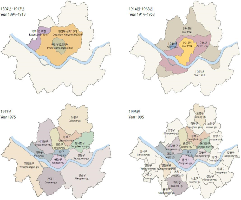
In the Joseon Dynasty, Seoul’s administrative districts spanning 4km outside the city walls called “Seongjeoshimni” were extended to 134㎢ in 1939 as Yeongdeungpo was developed as one of Japan’s military industrial bases. In 1945, Seoul had 8-gu (districts) and 268-dong (neighborhoods). After liberation from the Japanese regime, Seoul was renamed and upgraded to the Metropolitan City of Seoul. After that, 45-ri (small towns) were integrated into Seoul and organized into 9-gu along with the newly established Seongbuk-gu, and the total area of Seoul increased to 268.35㎢. In 1963, Seoul integrated 5-gun (towns) and 84-ri nearby, expanding its area 2.3 times to a total of 613.04㎢. Additionally, in 1973, part of Gyeonggi-do (province) was integrated into Seoul, expanding the area of Seoul to 627.06㎢.
Afterwards, Seoul set up and adjusted the autonomous districts and slightly adjusted the total administrative area of the city, which was also readjusted due to physical measurements. In 1975, the area south of Hangang was separated from Seongdong-gu to form Gangnam-gu, and in 1977, part of Gangseo-gu was separated to form Yeongdeungpo-gu. In 1979, the number of gu grew to 15, including the newly formed Eunpyeong-gu and Gangdong-gu. The number increased to 17 with the addition of Guro-gu and Dongjak-gu. In 1988, Songpa-gu, Jungnang-gu, Nowon-gu, Seocho-gu and Yangcheon-gu were established, and in 1995, Gangbuk-gu, Geumcheon-gu and Gwangjin-gu were created in order to complete the current 25-gu organization of the city.
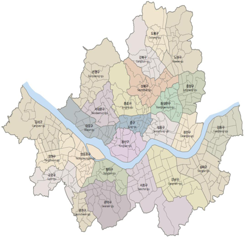
As of the end of 2010, Seoul consists of 25 autonomous districts and 424 villages spanning an area of 605.25㎢, making up approximately 0.6% of the total area of the Republic of Korea (100,033㎢). In 2012, the number of villages decreased to 423 as Myeongryun3ga-dong, Jongno-gu was combined with Hyehwa-dong.
<Figure 6> Changes of Administrative Districts (1394-1995)
<Figure 7> Administrative Villages (2010)
<Table 1> Changes to Administrative Districts
| Year | History |
| 1945 | Gyeongseong-bu renamed to Seoul with 8 gu and 268 dong |
| 1949 | Seoul upgraded to a Metropolitan City and the number of gu increased from 8→9 (area 268.35㎢) * 1st city expansion (integrating Sungin-myeon, Dokdo-myeon and Eunpyeong-myeon of Goyang and Dong-myeon of Siheung-gun and the newly established Seongbuk-gu) |
| 1963 | 9 districts (area 613.04㎢) * 2nd city expansion (part or all of the area south of Hangang (Yangju-gun, Siheung-gun, etc.) integrated |
| 1973 | 9 gu→11gu (area 627.06㎢) * 3rd city expansion (Integrating Gupabal-ri, Jingwannae-ri and Jingwanwoi-ri, Sindo-myeon, Goyang, Gyeonggi-do; Gwangak-gu and Dobong-gu newly established) |
| 1975 | 11 gu→12 gu |
| 1977 | 12 gu→13 gu |
| 1979 | 13 gu→15 gu |
| 1980 | 15 gu→17 gu |
| 1988 | 17 gu→22 gu |
| 1995 | 22 gu→25 gu |
| 2000 | 25 gu 522 dong (area 605.50㎢) |
| 2005 | 25 gu 522 dong (area 605.40㎢) |
| 2010 | 25 gu 424 dong (area 605.25㎢) |
| 2012 | 25 gu 423 dong (area 605.18㎢) |
<Figure 8> Changes to the Area of Administrative Districts (1939-2010)

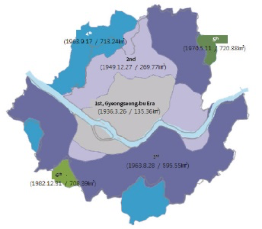
Changes to Urban Planning Zones
Starting from the first urban planning implemented in 1936 for Gyeongseong-bu, Seoul underwent 8 zone adjustments, including expansion of the city planning zones due to the increase of population and independence of some administrative zones. These zones are currently nearly identical with the administrative districts.
Seoul’s urban planning zones were first determined by the Gyeongseong-bu urban planning zones of the Japanese Government General of Korea Notification No. 180 on March 26th, 1936; at that time the area of Seoul was 135.36㎢. In 1950, 4 zones including Sungin, Eunpyeong, Guro and Ddukdo were integrated into Seoul, which now expanded to 269.77㎢, double the area compared to before the plan.
In 1963, the urban planning zones were expanded to all administrative districts, and part of Sindo-myeon, Pacheon-myeon, Ojeong-myeon and Seo-myeon of Gyeonggi-do were additionally integrated into Seoul’s urban planning, which now expanded the city area to 713.24㎢. After that, the planned population was adjusted and adjacent areas including Hwacheop-ri and Galmae-ri, Yangju-gun, Gyeonggi-do were integrated into the city’s planning zones, increasing the city area to 720.88㎢ in 1970.
However, Gwangmyeong-si was separated from Seoul in 1982 and Gwacheon-si and Bucheon-si were also removed from Seoul’s urban planning zones in 1991, decreasing the city area to 605.96㎢ in 1995.
<Table 2> Changes to Urban Planning Zones
| Effective date | Urban planning zones (㎡) | Remark |
|---|---|---|
| 1936.3.26 | 135.36 | Korea’s first urban planning project (Gyeongseong City Plan). |
| 1950.1.1 | 269.77 | 4 districts integrated (Sungin, Eunpyeong, Guro and Ddukdo). |
| 1963.8.28 | 595.55 | Total area expanded |
| 1963.9.17 | 713.24 | Part of Sindo-myeon, Pacheon-myeon, Ojeong-myeon and Seo-myeon of Gyeonggi-do were additionally integrated into the city plan. |
| 1970.5.11 | 720.88 | Hwacheop-ri and Galmae-ri of Yangju-gun, Gyeonggi-do were integrated into the city plan. |
| 1982.12.28 | 708.39 | Gwangmyeong-si separated from the city’s planning zones |
| 1991.7.15 | 665.98 | Gwacheon-si (35.81㎡) and Bucheon-si (6.59㎡) removed. |
| 1995.1.20 | 605.96 | Wonneung zone and Guri-si (5.80㎡) removed; area reduced without changes to drawing (0.28㎡) |
<Figure 9> Changes of Urban Planning Zones
Growth of Population and Expansion of the Developed Area
Growth of Population
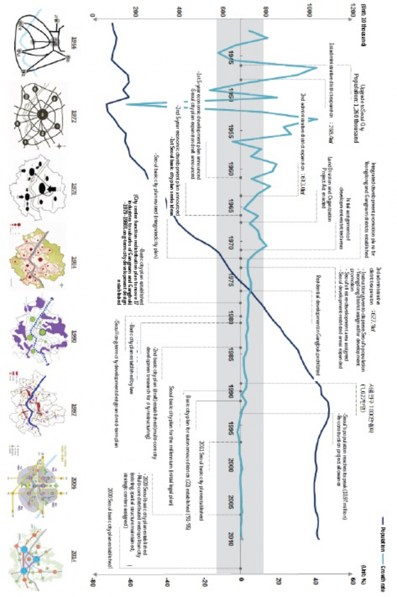
For the first time in history, Seoul’s official population was recorded in 1915 in the yearly statistic report of Seoul, which stated its population was approximately 240,000. In 1936, its population increased 79.9% YoY to 730 thousand, which was the result of the expansion of administrative districts. It exceeded 1 million for the first time in 1942, and after Korea’s liberation from Japan, it continued to increase as Koreans drafted for overseas labor by Japan as well as Koreans in Vietnam returned to Seoul. However, as the Korean War broke out on June 25th, 1950, Seoul’s population decreased by 61.7%. As population began to increase again after the war, Seoul’s population reached 1 million again in 1953. Thanks to the government’s strenuous efforts to rebuild the city, Seoul’s population became 2 million in just 6 years. It reached 4 million in 1968, and 8 million in 1979. In the 1980‘s as well, Seoul’s population steadily increased during the development of Gangnam, but in 1990‘s, population growth slowed down. Seoul’s population reached its record, 10.97 million in 1992 and began to decrease as suburbs were developed and birth rate decreased. As of 2010, Seoul’s population is 10.58 million (registered residents only). After almost 100 years of steady growth during the last century, Seoul’s population seems to have stabilized at a certain level.
<Figure 10> Population Growth (1915-2010)

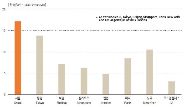
The population density of Seoul sharply decreased in 1949 and 1962 due to the expansion of administrative districts, but it steadily increased until the late 1990‘s. In 1963, it was 5,309/㎢ when Seoul’s administrative area was expanded to 613.04㎢, which is similar to that of today. However, Seoul’s population sharply increased in the 1960s, and by 1973, the city’s population density was 10,000/㎢ and again increased to 15 thousand/㎢ in 1983. Seoul’s population density reached its peak, 18,121/㎢ when its population reached a record high in 1992. However, population growth slowed down starting in the late 1990’s and the city’s population density decreased to 17,473/㎢ as of 2010. Compared to other major cities, Seoul’s population density (as of 2005) is one of the highest in the world. It is higher than Tokyo‘s (13,650/㎢), let alone New York (10,483/㎢) and Paris (8,401/㎢).
<Figure 11> Population Density Trend (1939-2010)

<Figure 11> Population Density Trend (1939-2010)
<Figure 12> Population Density Comparisons with the World‘s Major Cities
Expansion of the Developed Area
The developed area of Seoul during the Joseon Dynasty was limited to the area inside the walls of four gates. Towards the end of the 19th century, railways began to be developed as a modern means of transportation and as trains were operated, the developed area began to expand. Seoul underwent drastic expansion starting from 1963, when the city’s administrative districts began to expand, which caused to accelerate drastic industrialization and large-scale land organization. In the 1980’s, Korea changed from a single-core city to a multi-core one with Gangnam, Yeouido and Yeongdeungpo areas as the milestones. Seoul’s expansion stimulated the development of adjacent areas. The 1st new cities (Bundang, Ilsan, Pyeongchon, Sanbon and Jungdong) were developed in the 1990’s and the 2nd new cities (Seongnam Pangyo, Hwaseong, Gimpo, Paju, etc.) in the 2000‘s. With the development of the public transportation network, the metropolitan area of Seoul expanded even.
<Figure 13> Analysis of Developed Areas Using Satellite Images

Trend of City Development and Changes to Legal Regulation by Era
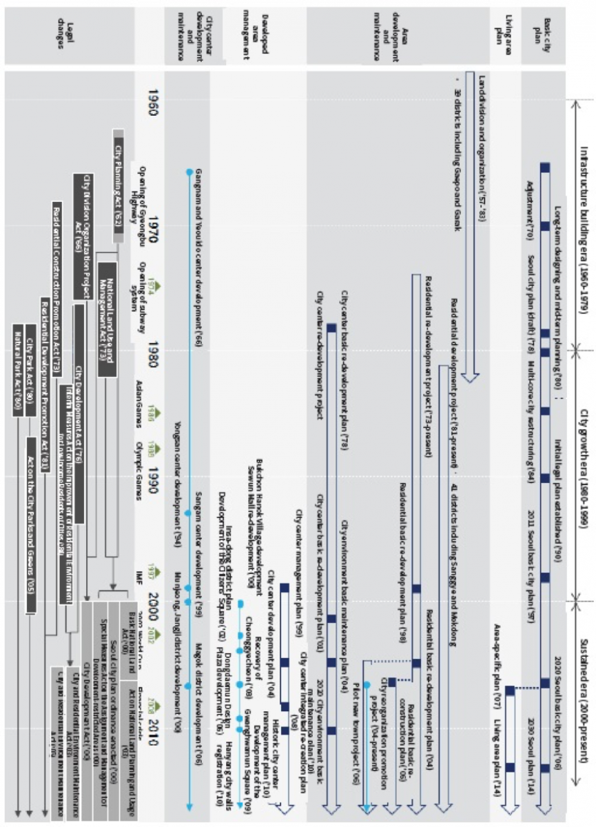
As mentioned above, Seoul has expanded and developed in terms of size and urban development until today. In the 1960s in particular, Seoul overcame the devastation of the post-liberation and the Korean War and developed into a modern city. The following is an overview of Seoul’s trend of city development and changes to legal regulations over 3 eras, which are the Infrastructure Building Era (1960-1979), the City Growth Era (1980-2000) and the Sustained Era (2001-2014).
Era 1: Infrastructure Building (1960-1979)
Population Growth Exceeding Development of Housing and Infrastructure (1960s)
In the 1960‘s, Seoul experienced an explosive growth under the national development policy executed by a powerful military government. At that time, Seoul’s population increased by about a half million every two years, which was the population of Boston, U.S. During this period, many illegal settlements were formed throughout the city, and the suburbs of Seoul were quickly integrated into Seoul, and rebuilt as new residential areas. By 1963, Seoul’s administrative districts absorbed Gangnam and the northeastern areas, and Seoul’s sized doubled to 594㎢ and its population exceeded 3 million. Along with these expansions and developments came many problems including traffic congestion, environmental issues, poor public transportation, dense residential areas and illegal settlements. To alleviate traffic congestion, Seoul expanded and improved roads, building arterial highways, overpass and underpass ways. With an objective to prevent traffic issues caused by pedestrians, many pedestrian overpasses and underpasses were also built. During this period, Cheonggyecheon was filled with concrete, and Seoul’s first overpass way, Cheonggye Overpass Way was built.
In 1967, Yeouido, an island which was flooded in the rainy season every year was raised and developed as part of the city spanning 3㎢. This area turned into a well-planned residential and business area, called Manhattan in Seoul, by the 1970‘s.
At the same time, as part of Seoul‘s major undertakings, illegal settlements were demolished and rebuilt as new developments. As a result, slums and red-light districts at the center of Seoul were decisively removed and replaced with department stores and large-scale high-rise apartments and stores like the Sewun Mall. In addition, the illegal settlements on the slopes around the downtown area were removed and replaced with apartment buildings for the citizens of 4 to 5 floors. As a result, in 1969 alone, approximately 400 apartment buildings were built. However, one of them collapsed due to poor construction, killing 73 people.
Seoul’s land organization work that began after liberation intensified over a large area until the middle of the 1980’s. This had had a profound influence on Seoul’s formation as it is today. The land organization work mentioned here includes the measures to develop and maintain the city and provide the city infrastructure and framework. In the 1960s, land organization work was done on Seogyo, Dongdaemun, Suyu, Bulgwang and Seongsan districts. This work was intended to distribute population and industrial facilities more widely. Single houses were developed and division of lots was conducted.
During this period, new legal regulations for city planning were implemented to resolve issues of the city, e.g. economic poverty and shortage of housing, transportation and infrastructure, etc. Prior to the 1960‘s, the Japanese General Government of Korea enacted the “Joseon City Development Decree,” but it was intended to contribute to Japan’s invasive wars rather than city development itself. Until the end of 1950‘s after liberation, this decree was divided into the “City Planning Act” and “Construction Act” in 1962, which formed the first city planning system established by the government of Korea. The newly enacted “City Planning Act” had contents added regarding improvements for poorly developed areas and established a systematic mechanism that requires resolution by the central city planning committee for city plans. In addition, the “Land Division and Organization Project Act” was enacted in 1966 to minimize public costs while maintaining infrastructure such as roads and parks. In other words, regulations on the implementation procedure, method and expenses for the land organization projects were prepared to contribute to wholesome development of the city and advancement of public welfare.
Building of Residences and City Infrastructure (1970‘s)
The 1970‘s was an era of drastic development for Korea. Korea’s national income increased from 250 USD to 1,000 USD between 1970 and 1977, most of which was the result of Seoul’s growth. In the heart of Seoul, there were many sewing factories and exporters for Seoul’s export-oriented light industry. More and more job-seekers flowed into Seoul for better lives, which stimulated the city‘s drastic growth. By 1975, Seoul’s population reached 6 million.
During this period, the tension between North and South Korea grew stronger, necessitating a new set of national defense strategies and zones for development restrictions. In other words, the growth of Seoul, located within North Korea’s missile shooting range was considered a risk to national defense, and measures to restrict Seoul’s growth were needed. In the same vein, the city functions concentrated in the Gangbuk area, which was also considered to be a risk, made it necessary to develop Gangnam. Accordingly, the land organization project was conducted on a large-scale area in Gangnam, and an arterial highway grid was built. Law enforcement facilities, high-end single house complexes, large-scale apartment complexes, gigantic shopping centers, high-rise business buildings and historic middle and high schools moving from Gangbuk were now located in this area. In addition, Yeouido’s development, which started in the 1960s, intensified in this period and the National Assembly buildings, high-rise business buildings and residential facilities were built there.
In 1973, Seoul’s administrative districts expanded to a total area of 605㎢, which is similar to that of today. Seoul’s rapid growth made it necessary to improve the city‘s infrastructure and continued city development. Accordingly, the old-fashioned trains installed at the dawn of the 20th century were removed in 1968. In 1974, Seoul’s first subway train line, Line 1, was built. Also, high-rise business buildings, luxury hotels, the trade center and Art and Culture Center were completed and large-sized facilities such as arterial highways, tunnels, bridges and sewage facilities were continuously built. Korea’s drastic growth after the devastation of the Korean War marveled the world, which called Seoul’s achievement the “Miracle of Hangang.”
The 1970’s was a period when drastic industrialization and economic growth began in Seoul, which necessitated a new city plan administration and legal regulations of various sectors. In particular, the “City Planning Act,” which was thoroughly revised in 1971, required development restriction zones to control disorderly city growth and spread and complement the regional zoning system. It also upgraded the project to develop poorly developed areas to the redevelopment project and enacted a project implementation procedure. In addition, the “City Redevelopment Act” was newly enacted in 1976 to prevent aging of the city center and control illegal houses in the suburbs with the legal system. In addition, the “Act on Promotion of Residence Construction” (1973) and “Act on National Land Use Management” (1973) were newly enacted to provide fundamental solutions to residence shortage and effectively plan and manage the national land.
Era 2: City Growth (1980-1999)
Large-scale Developed Area and City Center Development (1980’s)
In 1980, Seoul had grown into a metropolitan city of 8.5 million residents. Just 8 years later in 1988, the city had 10 million residents. Experiencing drastic economic growth, Seoul saw more diversified industrial structure compared with the past as well as the appearance of a predominant middle-income class. Although the powerful economic drive by President Park Jeong-hee seemed to have come to a sudden stop in 1979 when he passed away, Seoul’s social and economic changes in the 1980’s continued to drive city development beyond what was already present.
During this period in particular, Seoul hosted the Asian Games (1986) and Olympic Games (1988), which necessitated aggressive city improvements and cleaning. Seoul built a large arena, the Olympic Park and residences for athletes in Jamsil to meet these needs and embarked on improving the Hangang area. With these efforts, high water channels were built on the Hangang beach and sewage pipes were installed on both sides of the river to prevent water pollution. Along the river, the city highway was built to connect the Gimpo International Airport, city center and the Olympic Arena. Subway facilities were also built to relieve Seoul‘s traffic issues and prepare to accommodate visitors to the Olympics. In 1984, Line 2 was made available and in 1985, Lines 3 and 4 were also completed.
To repair slums within the city center and respond to the need for increased business space, city center re-development became more active in the 1980's. During this period, Seoul permitted over 70 city center re-development projects for high development density and tax incentives. With this city center re-development, the center of Seoul was restructured, and its traditional city structure was reborn as a new city. Along with that, the city also implemented its city design projects along Eulji-ro and Teheran-ro of Gangnam to enhance its function and appearance.
The city also embarked on re-developing poor developments and building residences to meet the government's residence supply goals. Accordingly, large-scale farmlands and forests in Gangnam, Mokdong, Godeok, Gaepo and Sanggye were converted into residential areas accommodating large apartment complexes. To overcome the shortage of housing, apartment construction was considered to be a profitable business, which led to Seoul's apartment construction boom. This changed Seoul’s outlook completely.
In the 1980's, Seoul began to see various issues caused by the concentration of population and industries in large cities. To provide a sustained supply of residences by making adjustments in residential areas and communities, the government revised the "City Plan Act" in 1981 to enhance the level of education, culture, medicine and social welfare and improve the city plan system. With the "City Basic Plan System" introduced, 3 steps of the system (Step: 1 Basic City Plan, Step 2: Re-organization of City Plan, Step 3: Annual Execution Plan) were established systematically and the "City Design System" was introduced to control land use more precisely. In addition, people were given more opportunities to participate in hearings and make comments. Furthermore, "Residential Land Development Promotion Act (1981)" and "Interim Measures Act on the Improvement of Residential Environment for Low-income Residents of Cities (1984)" among other sets of laws were established to supply a large amount of residences.
Improvements of City Infrastructure and Investments in Environment (1990‘s)
By the time the Seoul Olympics ended, Seoul had grown into a true metropolitan city of 10 million people with a 10 thousand USD national income per capita in the 1990‘s. Still, the city needed further improvements to meet the expectations of its citizens and the needs of the city’s new economic outlook.
In the 1990's, several public projects were implemented, including expansion of the subway train system. Four subway lines (5-8) were added and new bridges, highways, museums and concert halls were developed by the government and Seoul City. High-rise buildings constructed by the private sector totally changed the skyline of Seoul's city center and Gangnam. In addition, Seoul's developed area expanded to the restricted zones from the late 1980's due to ownership of passenger cars and construction of highway network. Therefore, 5 new cities including Bundang and Ilsan and suburbs continued to be developed as key locations of the metropolitan area. However, Korea faced a financial crisis and asked IMF for relief funds, which further led to unemployment and other urban issues related to labor relations, homelessness and social welfare.
In the meantime, the restoration of Namsan, which was undermined by excessive growth and development, was called for. As a result, the "Namsan Restoration" project plan was confirmed in 1990. This project was promoted thanks to the efforts of the civil counsel consisting of experts, general public and local residents and aimed to demolish the ugly apartment buildings for foreigners and move the National Security Planning Agency and the Capital Defense Command as its key objectives. The original location of the Capital Defense Command now accommodated the Namsan Hanok Village, which aimed to replicate the Namsan Village of the Joseon Dynasty. Celebrating Seoul's 600th birthday, the apartment buildings for foreigners were also demolished in 1994, making Namsan's beauty more visible. This showed how important it was to manage city centers that are rich with historic resources.
In addition, the local government system was also introduced, which changed the hierarchical city management and planning to a participation-based system. Seoul’s 25 autonomous districts were now given considerable authority, which facilitated various district-oriented plans, facilities and activities.
As such, in the 1990's, the "Metropolitan Plan Zones" were newly established to install and manage facilities requiring repair and maintenance, e.g. roads, railways and a water supply system. Also, a "Detailed Plan System" was adopted to assign the purpose, number of floors and floor area of individual structures in certain areas. Democracy and locality were now more valued, and a large portion of the authority for urban planning originally held by the Minister of Construction and Transportation was now assigned to municipal and provincial governors. By requiring the Minister to hear the comments of the local parliament, it was now easier for local residents to voice out their thoughts on development.
Era 3 : Sustained (2000-present) : Sophisticated City Management and High-quality Participation (2000’s)
Having completed the Olympic Games in 1988, Seoul became an international city. Her influence spread worldwide, and it became part of one zone with nearby localities. The local government era began and Seoul's ordinance for city planning was enacted in July 2000. In other words, matters assigned to Seoul's local governments were now handled by this ordinance. Along with this change, Seoul's city development policy changed from a growth-oriented policy to a sustained one.
After celebrating its 600th birthday in 1994, Seoul established a series of plans, including the City Center Management Plan (1999), City Center Development Plan (2004), City Center Integrated Re-creation Plan (2008) and Historic City Center Management Plan (2010). Seoul also conducted other various projects to return vehicle-dominated roads back to pedestrians. For instance, the Seoul Square, Sungnyemun Square and Gwanghwamun Square were developed to restore the historical values of those locations and an open space was provided in the city center. Also, the restoration of Cheonggyecheon, development of parks around Dongdaemun Stadium, development of the Open Namsan, etc. created ecological city spaces for nature and humans, especially good for pedestrians. In addition, the Bukchon development project helped restore Bukchon as a key historical resource. Seoul's city walls were also restored for UNESCO's recognition as a world cultural heritage.
Seoul’s New Town business helped close the gap between Gangnam and Gangbuk and repair and maintain infrastructure. In 2002, the pilot New Town project was implemented in Eunpyeong, Gireum and Wangshimni districts, and until 2007, a total of 26 districts benefitted from the New Town projects.
In 2002, Seoul converted the Nanjido Landfill located in Sangam district in the western area of Seoul and developed it into an ecological park and built the World Cup Main Stadium and Eco Village as a host of the 2002 World Cup. Presently, the city is also developing the Sangam Digital Media Complex, as an advanced digital media and entertainment cluster here.
Seoul also established the Hangang Renaissance, Northeast Renaissance and other zone-specific plans and is currently developing the Yongsan International Business District and Magok District. The City is also making strenuous efforts to improve its city design to enhance its appearance as an advanced city. Furthermore, it is developing parks, e.g. Dream Forest, Seoul Forest, Pureun Arboretum and various trails, e.g. Seoul Walls trail connecting parks and the Seoul Walls; Seoul Dulle trail connecting the outer four mountains and nearby hills; pedestrian and bicycle paths connecting Hangang and branch streams; and ecological and cultural trails. Through the Gangdong Greenway, Design Road, etc. the city is helping pedestrian traffic and assigned car-free streets for those who enjoy walking. These and other efforts made by Seoul have helped it to become a well-balanced historic and cultural city as well as an international city. During this period, participation and communication between citizens became more important. In fact, citizens of Seoul are now invited to participate in the 2030 Seoul Plan and other subsequent community development plans.
At the dawn of the new millennium, Korea’s city planning system changed drastically, reflecting the changes made in the society. Accordingly, the City Plan Act (2000) was heavily revised. As cities expanded and transportation and communication developed, communities also expanded. To control growth, a metro-city plan was adopted to apply to at least two administrative districts. In addition, unreasonable restrictions were also removed by allowing people to claim land purchase halted by long-term city plans. To prevent arbitrary developments, development is now allowed only after the plan is confirmed. Also, development-restricted areas, including their assignment and changes to them are now separately governed by Special Measures Act on the Assignment and Management of Development-restricted Areas (2000).
These revisions made to the City Plan Act in the 2000’s originated from a new trend of reconsidering urbanization and environmental damages and relieving unnecessary restrictions and excessive development after the financial crisis towards the end of the 1990’s. In other words, the development and growth-oriented development paradigm has now shifted to a more ecological and sustainable one, thanks to legislative improvements.
At the same time, the City Plan Act for cities and the National Land Use and Management Act for non-city areas were combined and reorganized to centralize the land use management system. To be more specific, the City Plan Act (1962) and the National Land Use and Management Act (1973) were combined in 2002 into the Act on National Land Planning and Usage. Also, the city designs and detailed plans defined for similar objectives were combined into district-specific plans. Also, the city development provisions of the City Plan Act and Land Division and Organization Project Act were combined into the City Development Act (2000). The City Re-development Act (1976) and Interim Measures Act on the Improvement of Residential Environment for Low-income Residents of Cities (1984) were combined into the City and Residential Environment Maintenance Act. As such, correlated or redundant city plan systems were combined and centralized to make legal regulation simpler and more specific. In the 2010’s, the need for restoration and maintenance of the old city infrastructure and residences emerged due to a decrease in population, change of the industrial structure, uncontrolled expansion of city areas and aging of the residential environment. To meet this need, the Special Act on City Restoration Promotion and Support (2013) was enacted.
<Figure 14> Changes to the City Plan System
Changes to the Center Structure of Seoul
Since its designation as the capital of the Joseon Dynasty, Seoul has been performing its role as the capital of the country. Seoul’s spatial structure changed from a single-core to multi-core city from the Joseon Dynasty and Japanese regime to the modern era, which saw drastic increases in population, heavy industrialization and the demand for public services.
Since the 1960’s, Seoul has gone through changes as a multi-core city as defined in Seoul’s basic city plan. However, the number of city centers changed from 1 city center and 6 sub-centers in 1966, to 3 city centers, 7 metro-centers and 12 local centers.
Since the 1960’s, Seoul has gone through changes as a multi-core city as defined in Seoul’s basic city plan. However, the number of city centers changed from 1 city center and 6 sub-centers in 1966, to 3 city centers, 7 metro-centers and 12 local centers.
<Table 3> Changes to City Centers as per Basic Seoul City Plan
| 구분 | 1966 | 1972 | 1978 | 1984 | 1990 | 1997 | 2006 | 2014 |
|---|---|---|---|---|---|---|---|---|
| City center | 1 city center (within 4 gates) | 1 city center | 1 national center | 1 core (center) | 1 city center | 1 city center | 1 city center | 3 city centers (Hanyang Walls, Yeongdeungpo, Yeouido, Gangnam) |
| Sub-center | 5 sub-centers (Changdong, Cheonho, Gangnam, Yeongdeungpo, Eunpyeong) | 7 sub-centers (Mia, Mangwu, Cheonho, Yeongdong, Yeongdeungpo, Hwagok, Eunpyeong) | 3 cores (Yeongdong, Yeongdeungpo, Jamsil) | 5 sub-centers (Sinchon, Cheongnyangni, Yeongdeungpo, Yeongdong, Jamsil) | 4 sub-centers (Yongsan, Wangshimni, Cheongnyangni, Yeongdong, Yeongdeungpo) | 5 sub-centers (Yongsan, Wangshimni, Cheongnyangni, Yeongdong, Yeongdeungpo, Sangam, Susaek) | 7 metro-centers (Yongsan, Jamsil, Cheongnyangni, Wangshimni, Changdong, Sanggye, Sangam, Susaek, Magok, Gasan, Daerim) | |
| Local center | 7 local centers (Yeongdeungpo, Yeongdong, Suyu, Jamsil, Janganpyeong, Susaek, Hwagok) | 13 sub-centers (7 in Gangbuk, 6 in Gangnam) |
11 local centers | 11 local centers | 12 local centers (Dongdaemun, Mangwu, Mia, Seongsu, Sinchon, Mapo/ Gongdeok, Yeonsinnae, Bulgwang, Mokdong, Bongcheon, Sadang, Isu, Suseo, Munjeong, Cheonho, Gildong) |
|||
| District center | 27 district centers 157 neighborhood centers |
50 district centers | 59 district centers | 54 district centers | 53 district centers strategic developments (Yeonsinnae, Sanggye, Mangwu), Strategic developments (Sangam/ Susaek, Magok, Munjeong) |
Same as the existing plan |
<Figure 15> Growth and Spatial Structure Changes of Seoul
Implications
Since 1394 when it was designated as the capital of the Joseon Dynasty, Seoul has been Korea’s capital city. Between 1910 and 1945, Seoul experienced various spatial changes due to Japanese control. Between 1950 and 1953, Seoul suffered material devastation as the Korean War broke out and destroyed residences, commercial structures and public agencies. In the 1960’s, however, a powerful military regime appeared and enabled remarkable growths. Explosive increase of population and expansion of administrative districts resulted in illegal settlements, extreme density, traffic congestion and environmental pollution, etc., but Seoul continued to grow in a material point of view. New areas and countless roads were built in Seongbuk and Gangbuk, and Gangnam began to be developed to disperse functions concentrated in Gangbuk. In addition, development restrictions were imposed in the capital area to control excessive external growth of Seoul. Seoul’s growth continued in the 1980’s as well. In 1986 and 1988 in particular, Seoul hosted the Asian Games and Olympic Games, which stimulated the city to embark on aggressive improvements. A large-scale stadium was built in Jamsil, Hangang was improved, and the re-development plans of subway system and city center were implemented among others. To improve the city’s image, poor developments were re-developed and residences were built in Gangnam, Mokdong, Godeok, Gaepo and Sanggye to meet the sharply increasing demand. In the 1990’s, the subway system was expanded and various other public projects were started to change the city’s outlook completely. However, Seoul faced a financial crisis in 1997 and the need for even more changes emerged. From the 2000’s until now, the trend changed to value quality rather than quantity of development. As the host of the 2002 World Cup, Seoul developed the Sangam district, restored Cheonggyecheon and began the city center re-creation and Hangang Renaissance projects to enhance the quality of development.
In the future, Seoul will continue to grow. First, Seoul needs to improve quality of development because the population will stay at the current level due to the trends of lower birthrates and aging. In other words, it is imperative that Seoul enhances the quality of its city infrastructure. To that end, Seoul needs to select and focus on improvement opportunities rather than initiate large-scale development projects. Second, Seoul must seek sustainable development to preserve the environment and resources for future generations, rather than continue to waste resources. In fact, many green areas, open spaces and farmlands have been damaged in the name of development. However, resources are always limited and need to be preserved for future generations. Therefore, Seoul needs to improve parks and green areas and become a pedestrian-friendly city to ensure sustainable and systematic management is implemented. In other words, traditional hierarchy must be rejected, and participation of the citizens in the development of the city should be encouraged. In addition, the planning system should also be improved to ensure main and sub plans work together harmoniously. To meet these needs, Seoul is making extra efforts to hear the voices of the citizens as it pursues the 2030 Seoul Plan and community plans.
In the future, Seoul will continue to grow. First, Seoul needs to improve quality of development because the population will stay at the current level due to the trends of lower birthrates and aging. In other words, it is imperative that Seoul enhances the quality of its city infrastructure. To that end, Seoul needs to select and focus on improvement opportunities rather than initiate large-scale development projects. Second, Seoul must seek sustainable development to preserve the environment and resources for future generations, rather than continue to waste resources. In fact, many green areas, open spaces and farmlands have been damaged in the name of development. However, resources are always limited and need to be preserved for future generations. Therefore, Seoul needs to improve parks and green areas and become a pedestrian-friendly city to ensure sustainable and systematic management is implemented. In other words, traditional hierarchy must be rejected, and participation of the citizens in the development of the city should be encouraged. In addition, the planning system should also be improved to ensure main and sub plans work together harmoniously. To meet these needs, Seoul is making extra efforts to hear the voices of the citizens as it pursues the 2030 Seoul Plan and community plans.
References
Go, Se-bum, 2013, Changes to Residences with Small-sized Apartment Development: Seoul’s Land Division and Organization Districts, Ph. D thesis, Graduate School, Seoul National University
Korea Planning Association, 2009, City Plan Theory, Boseonggak
Seoul Development Institute, 2001, Seoul’s 20th Century History of Spatial Changes, Seoul Development Institute
Seoul Institute, 2013, Seoul in Map 2013, Seoul Institute
Seoul Metropolitan Government, 2009, Assessment of Seoul’s Planned Centers and Research on Hierarchical Reorganization, Seoul Metropolitan Government
Seoul Metropolitan Government, 2014, “2030 Seoul Basic City Plan” Main Report, Seoul Metropolitan Government
Lee, Tae-il, 2001, 21st Century’s City Development Direction and Role of the Public Sector, Korea Land and Housing Corporation
Applicable Laws
Act on National Land Planning and Usage
Enforcement Decree, Act on National Land Planning and Usage
City Development Act
City and Residential Environment Maintenance Act
Seoul City Plan Ordinance, Seoul Metropolitan Government
Enforcement Decree, Act on National Land Planning and Usage
City Development Act
City and Residential Environment Maintenance Act
Seoul City Plan Ordinance, Seoul Metropolitan Government