Urbanization Planning of Seoul
ISSUES
How to provide skyrocketing population of millions with housing, jobs, and utilities?
The population of Seoul increased from 1.57 million in 1955 to 2.45 million in 1960, increasing by some 180 thousand per year and by 900 thousand in 5 years. Population density also increased by 54% from 53 to 96 persons/ha. Population density in the downtown area was particularly high, recording 215 persons/ha in Jongno-gu, 275 persons/ha in Jung-gu, and 246 persons/ha in Dongdaemun-gu. Since urbanization and industrialization was accelerated thereafter, the influx of the population continued, recording 5.44 million in 1970, 8.36 million in 1980, and 10.61 million in 1990. The population growth rate of 30 years from 1960 to 1990 reached 270 thousands per year on average. Urban sprawl due to rapid population growth in the city without infrastructure threatened both people’s lives and sustainability of the natural environment. Improving previous residents’ poor living quality was important, and so was preparing measures to accommodate newly incoming population properly. These changes were problematic not only for humans. As explosively increased people settled in the hill or near waterways, the unregulated urban expansion encroached on the natural environment and the problems of natural destruction and pollution became serious. Some squatters occupying the government-owned land exacerbated the lack of public space, which was necessary for the city to function.
Figure 1. The population and population density growth in Seoul (unit: persons/km2)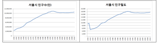
Endless Problems of Rapid Urbanization and Need of Urgent Actions
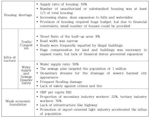
Rapid population growth and resultant high urban density in Seoul demanded solutions in various fields including transportation, sanitation, water supply and sewage system, green space, housing, economy and job creation, and public finance. Recovering the sustainability of the natural environment was also an important task.Such an urban problem was rapidly deteriorating due to explosive population growth. In a situation that the city government did not have enough capacity to solve such problems, the urban squatters mass-produced shanty towns near hills, streams and railways, where they were exposed to the poor environment vulnerable to sanitation, safety, fire, etc. Further, overcrowding in Seoul generated serious transportation problems. Due to the lack of proper streets (street ratio in the urban area was only 8% in 1961) and shortage of bus and tram, traffic congestion was severe and the public transport was crowded and inconvenient. Seoul was packed out. Lack of place to live, people penetrated into anywhere if there was a space to lie down. Those who arrived in Seoul earlier gathered near waterways and late comers settled up in the mountain. To build house, they used materials abandoned in construction sites, which included mould fragments, barrels, and lumps of scrap metal, and such houses gathered to form towns. Consequently, shanty towns sprang up in the waterside of Cheonggyecheon and Ichon and in the hills of Majang-dong, which became barren since trees were cut for firewood. Illegal squatter towns were everywhere. Fire could be a total disaster in these towns. Since the major construction material of the shanty town was the wooden board, also used for firewood and houses adjoined each other tightly, even a small fire could be unstoppable. Further, people could not escape promptly because proper roads were not enough in such towns. For example, a fire in a shanty town in Changsin-dong burnt 159 households in one hour, leaving 817 people homeless. At the time, Seoul’s water supply ratio was 56%, lacking in capacity to supply water in the urban areas. This statistics could not reflect ‘unauthorized’ houses. Sewage and pollution problems were also serious. Cheonggyecheon, a stream in the center of Seoul was a huge sewer full of garbage. In addition, flooding disasters occurred consistently. Roads were packed with cars. Since the road was prohibitively insufficient, increased cars congested the road. A lot of people who came to Seoul to make money became the outlaws, committing many crimes. Shanty towns, drinking water shortage, flooding and disaster, lack of infrastructure, high unemployment rate and various crimes abounded in Seoul.
Table 1. Issues and conditions of Seoul’s rapid urbanization in the 1960s

Lack of public finance and capacity
Since the budget of the Seoul city government at the time was very limited at the level of 1.8 billion KRW, the proper improvement of urban districts was almost impossible with the budget. For example, the covering of 1.4 km of Cheonggyecheon in the early 1960s for the sanitation issue was estimated to cost 1.4 billion KRW.Even before the mid-1960s, some attempts had been made to provide housing sites, disperse population and function through developing sub-centers, and improve urban districts’ sanitation, crimes and fire problems. Further, efforts to improve transport infrastructure and public facilities were made to resolve traffic congestion and to improve urban environment. However, such attempts turned out to be unsuccessful. Finance was insufficient and some attempts in the unauthorized substandard houses and shanty towns repeated failure. Since the mid-1960s, the Seoul city government changed its intervention strategy to more aggressive urban planning and new urban area developments.
Seoul Metro Area Urbanization Planning
Establishment of the Seoul Metro Area Plan
At the time, the major goals of the Seoul municipality in the urban development included improving economic efficiency, resolving traffic congestion, solving hygienic problems, enhancing safety, security and order, and securing the sustainability of natural environment. Planning and its implementation to achieve these goals was the key task of the municipality. Through urban planning, the Seoul city government tried to achieve efficient use of land resources, improvement of physical environment, better supply of public utilities, and sustainable development of human beings and natural environment. As the importance of urban planning was emphasized in the early 1960s, the Seoul municipality established a new urban planning bureau in 1961, and the urban planning law and building codes were enacted in 1962. Since the population was expected to grow up to 5 million due to continuous population growth, the administrative boundary of Seoul was doubled in 1963 by annexing the southern area of the Han River. Afterwards, the Seoul city government set up its urban development direction through establishing 10-year administrative policy plan in May 1965.
Figure 3. Change in Administrative District of Seoul and Its Area.
(Notice) Detailed Map will be renewed after additional verification(August, 30, 2021)
In January 1966, the Seoul municipality announced a plan to develop the new city of Gangnam in the newly annexed lands south of the river. The newspapers at the time reported that ‘blue print will be completed within this year, some housing will be built in September of 1968 and South Seoul development will get into stride.’ However, the plan’s contents were poor. Until that time, the Seoul city government had never created a new town plan or new urban district plan. Further, it had not enough capacity to realize such plans. Hyun-ok Kim being appointed as a new mayor in April 1966, Seoul’s urban planning and development projects entered into a new phase. Even though urban planning existed before that, it had limits in reflecting Seoul’s explosive growth. Based on the population projection, the Seoul city government established the comprehensive and long-term ‘Seoul Metro Area Plan’ and announced it in 1966. This plan was a comprehensive and long-term plan, targeting the year of 1985. Compared to the previous plans which were limited to the physical plans such as zoning and street network, this comprehensive plan included social and economic aspects, and it was the first official plan opened to the public. The primary characteristic of its physical plan was that its spatial scope was beyond the administrative boundary of Seoul, approaching from the scale of metropolitan area. Considering the city was rapidly expanding, this comprehensive approach beyond the administrative boundary was effective.

While acknowledging the city’s external expansion, the city had another challenge of setting up the degree and range of such an expansion and embodying the city framework. While preventing overcrowding and accommodating population growth, the plan aimed to use minimum land, make the city compact, and concentrate development activities in main points, which prepared a foundation for the pedestrian and transit-oriented city.The plan set up Seoul’s expansion limit within 15 km radius from the city center and conceptualized the ring-shaped green belt around 10 to 15 km radius to prevent excessive expansion of the built-up area. Satellite cities were to be developed on the outside of the green belt in principle, and the Gyeongin axis was set up as an important corridor to strengthen Seoul’s connection with Incheon, the outer port of Seoul.Urban space within Seoul was divided into four concentric areas, composed of central business district, suburban area, green belt area, and surrounding area. Basic street network consisted of 13 radial lines and 4 circular lines. The plan significantly considered density and urban structure for the compact and sustainable pattern of urban growth as well as the implementation beyond planning.
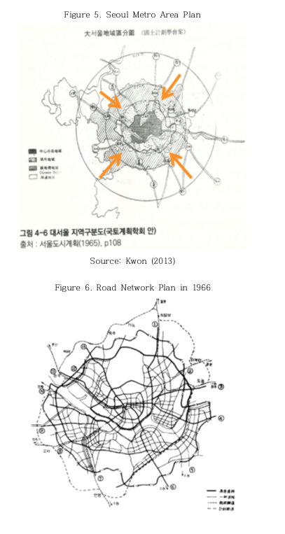
Seoul’s administrative district at the time consisted of the old capital area and its surroundings, but the plan also considered the southern area of the Han River and larger surrounding areas. Such an expansion was devised through calculating the occupied area per capita at the time and the population projection estimated 5.6 million people after 20 years from then.Promotion of sub-centers for the balanced development of the city was also an important feature of the plan. To distribute urban function, the plan proposed to relocate the legislative branch to the South Seoul, the judicial branch to Yeongdeungpo, and the executive facilities to Yongsan. The master plan included the plans for sub-centers such as Gangnam and Yeongdeungpo, but detailed plans including population redistribution and practical land readjustment strategies were materialized in the revised plan in 1970.
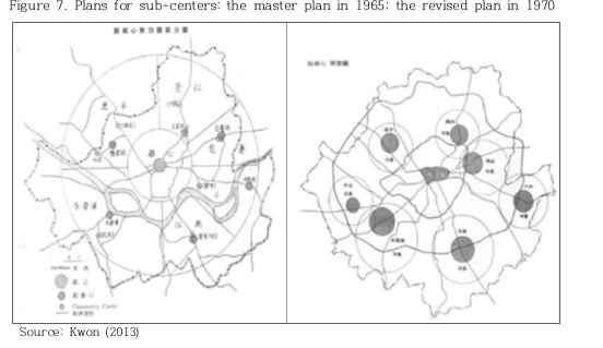
Table 2. Population and Spatial Plan for the Sub-centers (unit: 10,000 persons, km2)
Through administrative management for the plan’s implementation, Mayor Hyun-ok Kim strongly promoted the relevant projects all across Seoul, which included the Han River development, construction of toll ways, and various overpasses. In addition, he extensively implemented the land readjustment projects to materialize the land use plan. The land readjustment projects not only renovated existing urban area’s spatial structure, but also created new urban lands to prepare for the urban expansion.
Land Readjustment: Build Together, Benefit Together
The land readjustment project, defined as ‘a project related with exchange, subdivision or combination of land, transformation of the division, category or form of land, or changing installation of public facilities,’ enables materialization of new spatial order, securement of public space and provision of infrastructure. Initially, its primary goal was to improve existing urban area for the purpose of securing drainage for flood and fire prevention and improving resilience against disasters. Since the 1970s, it was also used in developing new urban areas and residential sites for the purpose of providing lands for the construction of houses and other urban facilities. Initially, the land readjustment projects strived to minimize public land to decrease the land contribution rate since the public sector was afraid of civil complaints. Consequently, re-expansion of public land such as arterial roads and other various types of wide and narrow roads (including fire road) was inevitable even before the completion of the project. To prevent such problems, the public sector began to take a long-term and aggressive position in its planning and development. The primary characteristic of the land readjustment was that the government could improve urban environment while significantly reducing its financial burden. Land owners provided 40 to 50% of their lands on average for the public use. Collected lands were utilized for the public facilities such as road, school and green space, while some of them were sold to cover development costs. There was no compensation for the provided land. However, the land readjustment improved the land’s accessibility, residential environment and infrastructure, which increased the land value. Due to the increased land value after the urban improvement, land owners could earn more profit than the value of the land they provided.

Although the re-plotting methodology had exclusively used the area as a basis, it compromised to consider the land value as well after 1963. As civil petitions increasingly demanded to reflect the price difference of the lands, the re-plotting system in 1977 adopted the street value evaluation method, which considered the variation of land price according to accessibility from the roads and others. Such an adaptation paved the way for the land readjustment to settle in the Korean local context.From the early to mid-1960s, the land readjustment projects in Seoul were mostly implemented in the north of the Han River and in a small scale. These projects primarily focused on the two-dimensional expansion. The early projects included the districts of Seongsan (1965), Bulgwang (1965), and Yeokchon (1967) in the west of downtown and districts of Myeonmok (1963), Suyu (1964), Ttukdo (1966), Changdong (1967), Hwayang (1967), and Mangu (1967) in the east of downtown. Even though vast areas were developed through the land readjustment, the housing shortage problem still existed because of the explosive population growth. In the late 1960s, the Seoul municipality promoted large-scale land readjustment projects in the south of the Han River, which included the districts of Yeongdong 1 (1968), Yeongdong 2 (1971), and Gyeongin (1968).The area of each of these districts was five to six times larger than those implemented in the early to mid-1960s. For the better land use efficiency, these districts adopted not only the detached houses, but also the apartment district, where the construction of apartments was compulsory. Further, the land readjustment projects applied the detailed and compact urban planning composed of low, middle and high density developments in the city center and sub-centers, which significantly contributed to the qualitative improvements of the urban area. The land readjustment in Seoul was implemented after the basic plan and design was set up to include considerations and countermeasures of the mobility between existing urban area and new urban district, and the expected changes in social, economic and cultural activities through new urban developments. Through these efforts, the land readjustment reorganized the whole urban structure of Seoul.
Achievements
Seoul changed rapidly. Even though its population increased by more than 3 million in 10 years, changing from 2.45 million in 1960 to 5.5 million in 1970, substantial improvements have been made in citizen’s quality of life, economic conditions, public services, green space, and so forth. Urban planning played a key role in keeping the changes orderly and economical to achieve its sustainable development.
Table 3. Seoul's Change in the 1970s
|
Category |
1970 |
1976 |
1981 |
|---|---|---|---|
|
Population (thousands) |
5,509 |
7,150 |
7,500 |
|
Per capita income (KRW) |
138,810 |
189,580 |
268,240 |
|
Urbanized Area (㎢) |
130 |
202 |
262 |
|
Housing (household) |
593,370 |
863,970 |
1,300,000 |
|
Per capita dwelling area(㎡) |
6.8 |
8.2 |
10.1 |
|
Production of Water Supply (10,000 ton/day) |
111 |
210 |
302 |
|
Area of total streets(㎢) |
34.85 |
44.57 |
55.69 |
|
Street ratio(%) |
9.5 |
12.0 |
15.0 |
|
Automobile |
61,000 |
170,000 |
315,000 |
|
Subway(km) |
- |
26.5 |
64.0 |
|
Per capita park area(㎡) |
4.04 |
5.73 |
6.60 |
In addition, spatially condensing developments through systematic planning could preserve more natural environments of Seoul and its surrounding areas. If Seoul was developed in the same density as New York in U.S., for example, more than twice urban areas than the current situation should have been developed to accommodate 10 million people. In other words, the dense development in Seoul led to the less environmental destruction than other cities. The Seoul city government has developed vast area of 140 ㎢ in total 58 districts through land readjustment. Development of such large area contributed to the healthy urban development and promotion of public welfare in the capital city, Seoul. Although securing land for public facilities was very hard in the built-up area, but the land readjustment project enabled the systematic securement of the lands for public facilities such as schools, roads, and parks. From the two-dimensional perspective, about 40% of total 350.5㎢ of developable lands in Seoul were developed through land readjustment, which played a decisive role in shaping Seoul as it stands now.