Seoul’s Sustainable Urbanization Planning and Land Readjustment
ISSUES
Rapid urbanization was threatening both life and nature
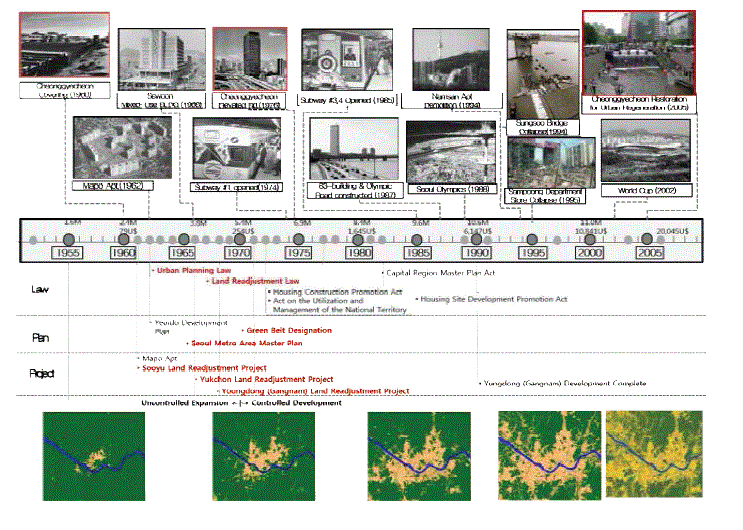
Since the 1960s, due to the rapid urbanization and industrialization that took place in the City, a massive influx of population migrated to Seoul. At the time when existing infrastructure was insufficient, the average annual population growth of 270 thousand (22,000 persons per month) only worsened the situation of the livability of Seoul. The incoming population had no place to stay, so they could not help settling in the mountainside and by the streams. This led to the proliferation of substandard living environments which were also vulnerable to natural disasters such as floods and
landslides. Also, this sort of settlement posed a greater problem: uncontrolled sprawl that destroyed the natural environment. These slums were causing serious deforestation of mountains and contamination of the streams.
.GIF)
SOLUTIONS
Set an order in land use; then build together benefit together
Subsequently, the need to establish a spatial order arose, especially to control the uncontrolled sprawl that was destroying sustainability of Seoul. Thus, the Seoul Metropolitan Government announced a preemptive spatial framework for the sustainable development – the Seoul Metro Area Master Plan
(1966), which was inspired by Greater London Plan (1944). This Master Plan aimed a compact, transit-oriented, and eco-friendly city. Seoul did not confine its plan to the administration boundary of those time. It tried to encompass the lives of future potential citizens (considering the growth), who will live, work, and commute beyond the City’s administrative boundary.
.GIF)
What made Seoul different from other cities is implementation. Planning itself is important, but what makes it substantive is the very act of realizing the plan: implementation is more crucial than a good plan. A plan should be accompanied with a sturdy implementation system which should include financial considerations, and the process of persuading citizens and relevant stakeholders. In the initial stage of urbanization, land readjustment served as the major implementation tool, which
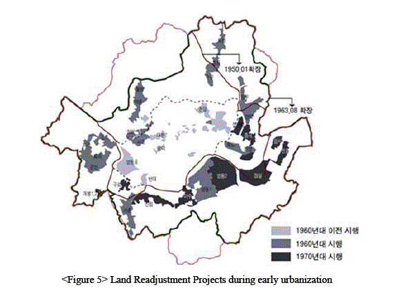
laid the foundation for the city’s forthcoming smart and sustainable development. The purpose of land readjustment was 1) to set a spatial framework for sustainable development, 2) to secure urban land with public space including roads, school sites, parks, and so forth, and 3) provide public services including water, sewage, energy, and so forth. Securing public space was the first step toward smart, sustainable, and resilient urbanization. Land readjustment enabled the Seoul Metropolitan Government to put a grid pattern urban structure
and secure much needed public space (e.g. percentage of roads was 8% in 1960) by receiving land contributions from citizens. At first, Seoul asked as little contribution as she could, for fear of citizen complaints. However, minimum contribution yields problems before the projects finished. For example, the roads were still insufficient and narrow so that many plots remained without accessibility of emergency services. The area confronted the necessity to re-expand public space.
Thus, from the late 1960s Seoul developed bold plans in order to embrace a long-term demand of public spaces and infrastructure for smart and sustainable development.
Roads deserve mention. Although roads make up the highest percentage of land use in public space, they do not only refer to the surface lanes for automobiles. Roads, not only provide space for ground transportation, but also their underground space serve as the city’s artery, or blood vessel, for citizens’ life and work, delivering water and sewage, electricity, gas, telecommunication, and heating & cooling to every part of a city. Roads are also crucial infrastructure for resiliency providing access for
rescue to emergency spots and place for people to escape. Accordingly, securing road space can be regarded as securing a network of necessary public space for the quality of citizens’ lives and the sustainable and resilient urban community.
.GIF)
.GIF)
Although residents contributed their land, in return, their land — which was previously unusable —would be developed into an urbanized land equipped with proper infrastructure, resultantly rising in land value that benefitted the owners. In other words, residents and the city would ‘build the city together,’ and then ‘benefit together’ the development gain that comes from building a well developed city.
In the initial stage of land readjustment in the early ‘60s, most of the project finance relied on public budget from national subsidy and municipal bond issuance. After the late ’60s, almost 100% for the project finance was covered by the sales of the portion of owners’ land contribution, instead of public budget.
.GIF)
ACHIEVEMENT
Sustainable Metro Area Planning
set a growth limit to protect nature from sprawl and citizens from disasters (e.g., flood, land slide, etc.)
Land Readjustment
(140km2) became urbanized through this tool. provided urban land and infrastructure for citizens’ life, work, learn, play, and move.
TIMELINE
CONTACT
DO YOU WANT TO GET MORE INFORMATION ABOUT THIS POLICY?
DO NOT HESITATE
E-MAIL US!!
international@seoul.go.kr
Department / Contact
- Urban Management Policy Bureau / Sung Pil Kang
- International Relations Division / 82-2-2133-5264 / international@seoul.go.kr
- Global Future Research Center / 82-2-2149-1418 / ssunha@si.re.kr