سياسة السيطرة على الفيضانات في سيول
Flood Control Policy Trends & Changes in Seoul
Background to Flood Control Policy Changes
Seoul is a city with an intense concentration of political, economic and other urban functions. Its population is dense, and its buildings and underground networks are intricately structured. Flooding in such a city would result in considerable loss as well as prohibitive costs and restoration time. The flood damage of July 2011 was caused not only by heavy rainfall that exceeded designed drainage capacity (the primary cause), but also by a number of other situations, such as surface runoff going to low-lying areas, insufficient flow capacity of sewage pipes, reduced conveyance due to sediment runoff, and backwater. There were also other reasons: road designs that failed to respond to climate change; vulnerable aspects of land use (e.g., underground arcades); inadequate warning/alert systems, ineffective traffic control, and poor management of vulnerable areas/facilities, in addition to poor restoration systems and disaster follow-up. Recent climate changes aggravated by global warming have brought about torrential rains and storms, and their increasing severity and frequency tends to compound the damage.
Around the world, global warming has shown its effect. Climate change has led to heavy rains, storms, and other full-scale damage in many countries. Large global cities are working to introduce new disaster prevention systems, to prepare themselves for climate change and remain safe. In South Korea, two thirds of the annual rainfall is typically concentrated during the wet season from June to September, usually in the form of monsoons, typhoons or torrential rains. The increasing volume of precipitation has led to an increase of intensity, and this tendency is clearly found during the summer months, which is why it is all the more important to prepare for potential disasters prior to the season. To be able to respond to extreme weather changes, Seoul has also improved its disaster management at the ground level. The paradigm was shifted to adopt more fundamental preventive measures and establish/execute an evacuation and restoration system so that the city could protect its citizens and their property and preserve urban functions.
To ensure that its flood disaster policy vision is consistently maintained, Seoul checked its disaster prevention system every time there was a major flood (in 1984, 1987, 1990, 1998, and 2001) and came up with mid- to long-term countermeasures to supplement the existing system. However, the city is seeing more extreme weather conditions and localized torrential rains, which inevitably leads to reduced conveyance, increased areas with impervious surfaces, changes with the drainage system, and inland flooding due to a reduced base flow. Over time, extreme weather conditions have become a common occurrence, while the extent of flood damage increases in scale. The inland flooding in the city caused by the torrential rains of 2010 and 2011 was the turning point after which the city decided to review its drainage and disaster prevention systems. Unlike other times, the heavy rains in July 2011 fell at a rate of 100mm per hour, which was more than the city’s capacity to handle. Some of the low-lying and riverside areas were flooded. Rain continued for a long time, weakening the ground and causing landslides. The annual maximum daily precipitation (300 mm) had already been exceeded, which wreaked havoc in its localized and concentrated form. This tendency is expected to worsen. Seoul therefore aims to adjust its existing disaster prevention plan to be more responsive to and ready for extreme weather conditions, and has been directing its focus on the improvement of the system to become better prepared for potential flooding in the city.
Flood Control Policy to Date
(1) Flood Control Policy
In 1984, 1987, 1990, 2001, 2010, and 2011, Seoul experienced major flooding caused by torrential rains. To minimize the damage from a recurrence, the city has been repairing and improving its flood prevention facilities since the 1990s, including the river embankments, rainwater pumping stations, and sewage facilities. Pursuant to the Basic River System Improvement Plan, the design flood volume was calculated and the design flood elevation was assigned by points. The levee height was determined based on levee clearance, depending on the significance of the river stream (national rivers with a frequency of flooding 100 – 200 years and local rivers, 50 – 100 years). The existing sewer pipes in Seoul were designed for 10 years’ (main) and 5 years’ usage (branch), and between 10 and 30 years for the retarding basin and drainage pumps. To upgrade the capacity lifespan in the vulnerable areas to 30 years, Seoul is working to upgrade the design standards for the sewage and pumping stations while installing rainwater reservoirs and other facilities to reduce the storm water runoff.
(2) The Restoration Plan of 1998
The flood damage in 1987 and 1990 was amplified by intensive rainfall over a prolonged period of time, which increased the runoff, which in turn increased the cumulative inflow to the retarding basin. The existing facilities did not have sufficient capacity for such prolonged precipitation. The drainage systems on higher ground overflowed with the abrupt onset of torrential rain flowing into the receiving reservoir. This in turn resulted in flooding in the low-lying areas. The reduced conveyance of the sewage pipes did not help either. Seoul therefore spent KRW 456.855 billion from 1999 to 2003 for the Restoration Plan of 1998, made up of some 369 projects in 6 different sectors such as river, sewage, and pumping stations. From 2002 to 2007, KRW 315.434 billion was spent pursuant to the 2001 Revision to the Restoration Plan of 1998 to execute 113 projects in 3 sectors – river, sewage, and pumping stations.
(3) The 4-year Flood Control Improvement Plan of 2007
The record rainfall in July 2001 wreaked havoc on Seoul. From 2002 to 2005, KRW 680 billion was spent to build more rainwater pumping stations, reinforce the river embankments, and expand the sewage system to be prepared for future flooding. In the meantime, global warming continued to cause extensive damage around the world. Typhoon Rusa (870㎜/day) in 2002, Typhoon Maemi (550㎜/day) in 2003, and Typhoon Nari (556㎜/day) in 2007 each set new records. The city had to heighten the capacity of its flood control facilities.
Fifty-two rainwater pumping stations were improved to the 30-year frequency. To ensure their safety, the electrical facilities of 111 rainwater pumping stations were doubly-reinforced. Some 28 km of segments along the embankments of 13 streams, such as Uicheon, were fortified to keep the overflow in check. Twelve dilapidated bridges that could impede the water flow were removed and/or rebuilt. The sewage systems were upwardly adjusted to achieve 10 – 30 years capacity in intervals. They were also repaired according to their age to ensure their stability and safety.
Increasing Flooding & Damage due to Urbanization and Climate Change
(1) Urban Development & Change in Size
The growth of Seoul accompanied the concentration of population and their assets. In Joseon Dynasty, the built-up area was confined to and around the walled city of Hanyang. By the time of Japanese colonial rule, Yongsan, Itaewon, and their vicinity were developed into a Japanese army post. The Japanese population slowly formed a village to the south of Cheonggye Stream –called Namchon (‘South Village’) – after the Korean seaports opened their doors to the outside world, and this area became the new center of commerce and business.
The 1960s was marked by rapid industrialization and urbanization, propelled by the first and second 5-Year Economic Development Plans. The concentration of population became even more accelerated, and the city’s urban planning districts were expanded to include the areas northeast and south of the Han River, or ‘Gangnam’. In the 1990s, the influence of Seoul spread and became even more far-reaching, and the city gradually shifted from its growth-oriented urban development policy to a sustainable urban development approach.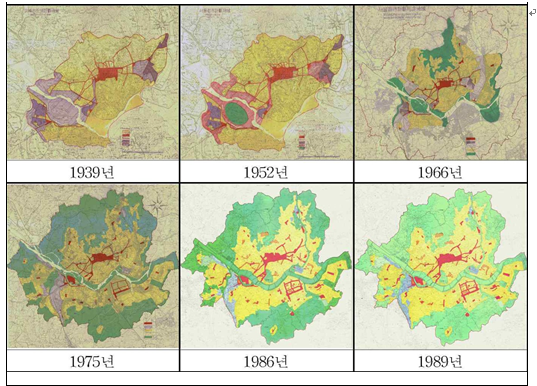
<Figure 1> Changes in Seoul’s Urban Development
(2) Increasing Population & Growing Percentage of Impervious Surfaces
The population growth of Seoul picked up speed after the Korean War. According to Statistics Korea, the population surpassed 1.57 million in the 1955 census; by 1960, it was over 2.44 million. Up until 1970, the city’s rate of population growth stayed at over 50% on an annual average. After that, the population continued to grow at 10 – 20% each year until 1990 until, by the early 1990s, the population was around 10 million.
In 1980, the city center was 240.35㎢, about 39.71% of the total area. By 2010, it grew to 349.65㎢ (57.77%). Farmland and forested areas were reduced from 115.96㎢ and 147.21㎢ respectively in 1980 to 22.09㎢ and 144.75㎢ in 2010. As of today, the arable land is 27.80㎢ (4.59%) of the total area (605.21㎢) of Seoul. The forested area is 145.62㎢ (24.06 %); the lot area is 216.54㎢ (35.78%), and other areas account for 35.57% (215.25㎢).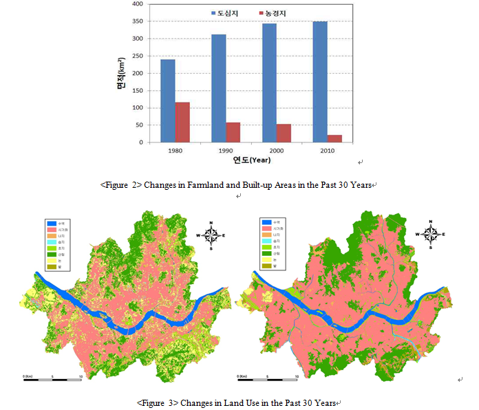
(3) Climate Change & Increasing Torrential Rains
For the last half century (1962 – 2011), Seoul’s average annual precipitation was 1,429.5㎜. The period between 1962 and 1971 was 1,498.4㎜, while recently (2002 – 2011) it has increased by 115.3㎜ to 1,613.7㎜. The annual rainfall in 1966, 1990, 1998, and 2010 was over 2,000㎜, but was 1,000㎜ or less in 1962, 1973, 1982, and 1988, which shows quite wide fluctuations. By season, the rainfall in the summer was 720.0㎜ (1972 – 1981), going up by 44.3% to 1,038.8㎜ in the period 2002 – 2011. In the winter, it dropped from 74.8㎜ to 62.1㎜ (17.0%), making it more vulnerable to flooding from summer rains. In the last 50 years (1962 – 2011), there were 6.5 days with precipitation of 50㎜ or more; between 1962 and 1971, it was 6.5 days, while it was 7.8 days between 2002 and 2011, up by 1.3 days. The number of days with precipitation of 80㎜ or higher was 3.0; it was 3.3 between 1962 and 1971, going up by 0.7 to 3.9 days in 2002 – 2011.
<Table 1> Changes in Precipitation by Decade for the Past 50 Years (1962 – 2011) in Seoul
|
Category
|
1962 – 1971
|
1972 – 1981
|
1982 – 1991
|
1992 – 2001
|
2002 – 2011
|
|
|
No. of Rain-days
|
50㎜ or more
|
6.5
|
5.3
|
6.7
|
7.5
|
7.8
|
|
80㎜ or more
|
3.3
|
1.9
|
2.6
|
3.5
|
3.9
|
|
With the frequency of downpours increasing, the years 2010 and 2011 saw unprecedented and relentless torrential rains. Seoul is unique in that the increase in the number of rain-days is not significant, while its annual precipitation is steadily rising. This indicates that the intensity of precipitation could grow, intensifying any flood damage. Generally, precipitation of 30㎜ or more per hour (a potential risk for disaster) happened 158 times in the last 50 years, which is an average of about 3.4 times per year. It was highest (14 times) in 1998; between 1962 and 1971, it happened 36 times, going up to 41 times in the period 2002 – 2011.
<Table 2> Occurrence of Torrential Rains (30㎜ or More per Hour) in Seoul
|
Category
|
1962 – 1971
|
1972 – 1981
|
1982 – 1991
|
1992 – 2001
|
2002 – 2011
|
|
No. of Rain-days
(30㎜ or more per hour) |
36
|
11
|
27
|
41
|
4
|
(4) Increasing Runoff due to Changes in the Impervious Surface Area
From the 1970s to the 1980s, there were no systematic measures to prevent flood disasters in the sites and commercial districts developed near the water and in low-lying areas. Some 40,000 out of 350,000 households living in basement units were located in areas vulnerable to flood risk. The loss of natural grounds in the city area reduced the permeable green zones under which water could be recharged. Naturally, the increasing area of impervious surfaces and pavement overloaded the drainage facilities. In Seoul, the impervious area went from 7.8% in 1962 to 47.7% in 2010. Surface runoff also jumped proportionately, from 11% (1962) to 49% (2010).
<Figure 4> Changes in Water Circulation due to Changes in Impervious Surfaces over the last 40 Years in Seoul
(5) Formation of Low-lying Areas
In flat areas or low-lying basins, the catchment of rain or storm water or the introduction of storm water from higher ground usually causes flood damage. In low-lying areas near a river, the effect of backwater, (combined with many other reasons), prevents the storm water from being expelled. For this reason, across Seoul, in a downpour of 40 – 60㎜ per hour, there are a number of areas that have a high risk of flood.
Frequent Flood Damage due to Torrential Rains
Extent of Flood Damage due to Torrential Rains
Unprecedented torrential rains fell in 2010 and 2011. The following gu districts suffered damage both years: Jongno-gu, Yangcheon-gu, Gangseo-gu, Guro-gu, Geumcheon-gu, Dongjak-gu, Gwanak-gu, Seocho-gu, Gangnam-gu, and Gangdong-gu. The annual loss was KRW 2.867 billion/year from 1965 to 1980, amplified 3.5 times to KRW 9.983 billion/year between 1981 and 2010. Into the late 1980s, the frequency and extent of flood damage grew steadily. In terms of the damage from building flooding, 2001 was the most serious year, followed by 1998, 1984, 1987, and 2010.
<Table 3> Major Flood Damage from Torrential Rains in Seoul
|
Damage Period & Precipitation |
Major Cause of Flooding |
Damaged Areas |
Damage |
|
1984 (8.31 – 9.2, 335㎜) |
Gate destroyed at the Mangwon retarding basin, Seongnae Stream flooding |
Major floods in Pungnap and Mangwon, |
Casualties: 43 |
|
1987 (7.26 – 27, 352.1㎜) |
Insufficient capacity at retarding basin and pumping stations |
Guro, Gaebong, Mangwon, Shinjeong, Banpo, etc. |
Casualties: 38 |
|
1990 (9.9 – 11, 486.2㎜) |
Torrential rain at upstream Han River; |
Major floods in Seongnae and Pungnap; |
Casualties: 36 |
|
1998 (7.31 – 8.18, 1,237.8㎜) |
Rising flood elevation; |
Flood from Jungnang Stream (Nowon, Dobong, etc.); |
Casualties: 19 |
|
2001 (7.14 – 15, 316㎜) |
200-year interval torrential rain; Insufficient capacity of the sewage system |
Flooding from Dorim Stream (in Gwanak, etc.) |
Casualties: 35 |
|
2010 (9.21, 259.5㎜) |
98.5㎜/hr (Gangseo) |
Most areas in Seoul, except for Dobong-gu and Nowon-gu |
Casualties: none |
|
2011 (7.26 – 28, 587.5㎜) |
113㎜/hr (Namhyeon) |
Landslide at Umyeon Mountain in Seocho-gu and major floods in Gangnam area |
Casualties: 16 |
<Figure 7> Major Flooded Areas in Seoul (1984 – 2011)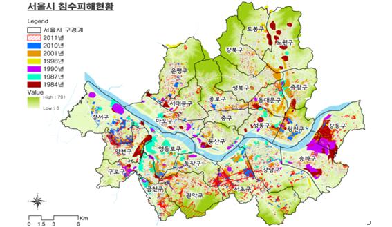
There are 300,000 basement housing units in the city, with 40,000 of them are located in flood-prone low-lying areas. The sewer pipes for basement housing are installed lower than the public sewage system, and they regurgitate when it rains. Furthermore, a massive volume of storm water was also introduced into the low-lying areas, and the surface runoff flowed into the basement housing.
.PNG)
(2) Flooded Underground Facilities
With the urbanization of Seoul, the city’s underground system (subway and underground motorways) was aggressively developed and is heavily utilized. However, these systems are extremely vulnerable to flooding when they are located in low-lying areas. When flooded, the subway in particular has a direct impact on the citizenry as the flooded tracks and stations cannot be used; the service could also be discontinued due to blackout, or transportation to the flooded area could be severed.
(3) Flooded Roads
Riverside roads are usually flooded due to rising river elevation, but in recent years, there has been an increasing number of floods in the low-lying areas of the city, caused by the lack of storm water facilities and insufficient capacity for sewage in the event of heavy rains. The number of flooded roads near the rivers and in the low-lying areas was 33 in 2010, 28 in 2011, and 7 in 2012, all requiring traffic control.
(5) Flooded Rivers
When the rain exceeds the capacity of the design or there are facility interruptions to the flow of the river, the river elevation rises and ultimately causes flooding in the riverside low-lying areas. The effect of backwater in particular reduces the capability of the sewage system to expel the inland flooding, further aggravating the damage.
(4) Landslides
On the lower part of a slope, the weakened foundation due to prolonged rain collapses and the earth slides down, potentially killing people and destroying property. On the hills in the city in particular, landslides could be worse due to the inadequate installation of ecoparks, walkways, and other artificial structures as well as the inadequate management of private land. Dilapidated stonework and retaining walls and mountain cut areas frequently collapse in torrential rains, but management is difficult as many of them are privately owned. In 2010, there were 33 landslides in Seoul. The following year, there were 50 landslides, including one on Umyeon Mountain. In 2010, building stonework and slopes collapsed in 4 locations, and in 31 locations in 2011.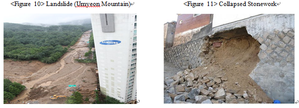
(6) Casualties in River Valleys
Hillside valleys and riversides in the city are frequently used for picnics during holidays in the summer. However, in and around the smaller rivers and valleys, the water level can rise quickly after a short period of downpour, leaving people isolated and in danger. At times, the rapid torrents have taken lives. In 2010, 69 people were rescued from the river valleys; in 2011, 38 were rescued and 2 remained missing. In 2012, 8 were rescued.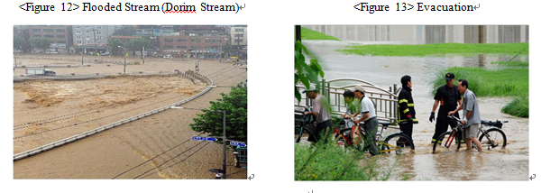
(7) Typhoons
A typhoon occurs when the warm air at a low altitude meets the vapor from the ocean and moves to a higher altitude, carrying with it strong winds and heavy rain. (In the summer, it brings heavy rain; in the autumn, it brings fierce winds). In 2010, Seoul was located in the danger zone to the right of the path of “Kompasu”; 20,000 trees fell, and an electric pole collapsed, cutting power to some 400,000 households.
Improvement of Existing Flood Control Policy
Reinforced Responsiveness to Torrential Rains
Seoul is unique in that the increase in the number of rain-days is not significant, while its annual precipitation is steadily rising, but this indicates that the possibility of a downpour can increase. In 2010 and 2011, 100㎜ of rain fell per hour, but this kind of heavy rain cannot be processed by the current facilities. In continuous heavy rain, as on July 27, 2011, the permeability of the ground is lost and runoff increases, seriously increasing the potential for disaster. Precipitation of 30㎜ or more per hour – a potential risk for disaster – has happened an average of 3.4 times a year over the last 50 years, and the number has jumped by 0.7 to 4.1 in the last 10 years (2002 – 2011). It happened 7 times in 2010, 8 times in 2011, and 9 times in 2013.
<Table 4> Extreme Precipitation due to Climate Change
|
Category |
July 2001 |
September 2010 |
July 2011 |
|
Precipitation |
99.5㎜/hr (Jongno) |
98.5㎜/hr (Gangseo) |
113㎜/hr (Namhyeon) |
※ Probable precipitation in Seoul (Ministry of Land, Infrastructure and Transport): 99.2㎜/hr (50-year timeframe), 243㎜/3hr (50-year timeframe)
Seoul’s sewage system can process the 5-year frequency for the branch (65㎜/hr) and the 10-year frequency for the main (75㎜/hr). Currently, the aim is to upgrade the capacity to 10 years (75㎜/hr) and 30 years (95㎜/hr) respectively. When a sewage system is designed, it assumes that 35 – 40% of the precipitation is permeated or evaporated, but in prolonged rain, the permeability of the ground is lost and runoff increases. When the sewage system already has water from previous days of rain, the system will no longer be able to process the water and its conveyance will be significantly reduced. In Seoul, 16.6% of the sewage system is 30 years or older, and this also contributes to the reduced conveyance. The rainwater pumping stations are being upgraded from a 10-year to a 30-year frequency, but as of today, only 49 out of 111 rainwater pumping stations have been upgraded to that 30-year frequency (95㎜/hr).
Urban Development Designed for Disaster Prevention
Rapid urbanization gave rise to the expansion of impervious areas. In addition, basement housing in the low-lying areas and the inadequate provision of systematic disaster prevention planning also left the city vulnerable to flooding. In the 1970s and ‘80s, developers moved from the built-up areas into the undeveloped low-lying areas for site and land development (Banpo, Jamsil, Cheonho, Amsa, Siheung, Gimpo, Seongsan, Shillim, Janghanpyeong, Guro, Mokdong, etc.). The built-up areas had been developed without a careful design for rainwater pumping stations and other adequate storm water facilities, resulting in flooding in the low-lying areas. The loss of natural grounds – green belts and farmlands – in the city reduced the permeable green zones under which water could be recharged. The impervious surface expanded in size, sending the surface runoff from heavy rain to the low-lying areas (runoff: 11% (1962) → 52% (2010) (impervious surface: 7.8% → 47.7% in the same time frame). Seoul in particular, has a heavy concentration of political, economic and other urban functions, and its underground space is heavily used. Flooding in the city would result in considerable loss as well as prohibitive costs and time for restoration.
Need to Move Basement Housing in Low-lying Areas
The development of the low-lying areas and the basement housing for low-income urban dwellers has left some 40,000 households exposed to flood risk. In these basement homes, floods occur even when the precipitation is less than the sewage capacity. This is because the water is regurgitated by the sewer pipes in the basement housing, which is installed lower than the public sewage system. In some areas, the runoff from the road surface flows into the basement through windows and doors. In many of these basement units, flood prevention facilities were not installed, and even where they were installed, they are not adequately managed due to lack of interest by the owner and on the part of the frequently-moving tenants. In the meantime, flood damage happens again and again.
Need for Responsiveness to Landslides
Landslides occur when a slope is made unstable by rain or other external factors and the weakened soil and rocks slide down. Due to the recent increase of heavy rain, Seoul has become more vulnerable to the risks of landslide. Landslides can happen as a result of natural causes (e.g., geography, soil, geology, planting, rain, groundwater, erosion, earthquake etc.), or artificially (e.g., land development or ground cuts). The damage is especially serious in those areas where the mountain torrents and cities meet, but as the mountains, roads, sewage, rivers, and such all entail different management plans, it is crucial to adopt a comprehensive system to manage landslides and ground foundation together.
Flood Control Policy for a Better Response to Climate Change
|
Category
|
Objective
|
Description
|
|
|
Maintenance and Expansion of Sewage System
|
․ To enhance the flow in the sewage system
|
․ Increase the number of pipes and capacity
․ Remove soil/sediments to enhance conveyance |
|
|
Construction and Expansion of Pumping Stations
|
․ To build and expand pumping stations to expel inland flooding
|
․ In city areas where the catchment is small
․ In areas where it is difficult to expel the inland flooding |
|
|
Flood Control
|
․ To install flood control sites and retarding basins
|
․ Store some of the flood water upstream of the areas where flood control policies are inplace (such as the inner city)
|
|
|
Flood-way Maintenance (Diversion Channel(s), Short-cuts, New Channels)
|
․ To change the basin area to divert some of the flood water to other basins
․ To install flood control facilities and underground diversion channels |
․ This can be a fundamental way to prevent flood damage, but the excessive construction costs are an issue.
|
|
|
Storm water Runoff Reduction
|
Storage
|
․ To minimize the flooding in the downstream area from the reduction of the flood peak
|
․ On-site or off-site methods (to be determined)
․ On-line and off-line methods (TBD) ․ Dams, excavation, underground structures (TBD) |
|
Absorption
|
․ To minimize the movement of rainwater to allow the rain to be absorbed where it falls
|
․ Select the target areas
․ Select the installation locations |
|
|
Category
|
Objective
|
Description
|
|
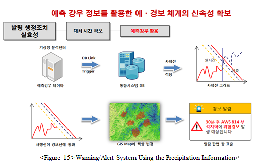
Flood Alerts
(Flood Alert System) |
․ Establish and improve the Flood Alert System
|
․ Improve the efficiency of the alert system to prevent flood damage
|
|
Storm & Flood Insurance
|
․ Provide government compensation and benefits from private storm and flood insurance; provide more information about the insurance system
|
․ As government compensation is limited and involves an extra tax burden, use of private insurance helps victims to be adequately and quickly compensated
|
|
Flood Maps
|
․ Identify the flood-prone areas by frequency and establish an evacuation plan
|
․ Lack of data from the past required to chart the map
|
|
Basin Management and Land Use Regulations
|
․ Control flood and sediment runoff
․ Control land use and construction |
․ Migration, restriction on land use, expropriation, advance sale, purchase of development rights, etc.
․ Restriction of building extensions, mandatory installation of prevention facilities in flood-prone areas |
|
Institutional Support
|
․ Develop a disaster management organization and planning system
․ Support restoration and secure funding |
․ Establish plans for emergency prevention and response.
․ Provide support with disaster funds, storm insurance, etc. |
|
Standards for Rainwater Use and Storm Water Runoff Facilities
|
․ Develop standards for the installation of rainwater-related facilities
|
․ Establish local government ordinances and a legal and institutional framework, and provide incentives
|
(1) Disaster Prevention Plan for Enhanced Responsiveness to Climate Change (2011)
|
Category
|
Total
|
No. of Rainwater Pumping Stations
|
Improved Pipe (㎞)
|
No. of New Rainwater Storage Facilities
|
No. of Divided Watersheds
|
River Improvement (m)
|
Other Grit Chamber
|
|
|
New
|
Expansion
|
|||||||
|
Programs
|
70
|
1
|
40
|
81
|
22
|
3
|
670
|
2
|
|
Cost (KRW 100 million)
|
6,693
|
115
|
2,500
|
2,281
|
1,140
|
543
|
87
|
27
|
|
Category
|
Total
|
Enhanced Sewer Pipe Performance
|
Improved Pipe (㎞)
|
No. of Rainwater Pumping Stations
|
No. of New Rainwater Storage Facilities
|
River Improvement (m)
|
No. of Deep Underground Facilities
|
Steep Slope Management, etc.
|
Other
(State Funded) |
|
Programs
|
|
47 divisions
|
154
|
47
|
25
|
45
|
7
|
Landslides, etc.
|
Areas with potential disaster risk
|
|
Cost (KRW 100 million)
|
50,201
|
21,551
|
7,952
|
4,923
|
2,040
|
432
|
8,502
|
4,600
|
201
|
(2) Disaster Prevention Programs Tailored to Local Needs (2011 – 2014)
Seoul aims to change its old way of relying on physical expansion of the facilities and involve the general public in developing disaster prevention plans that are tailored to local needs. Various issues are addressed in the programs, such as problems with the existing sewage pipes, improved water reclamation for flood control, and small, distributed rainwater storage. To control the flooding in the vulnerable low-lying basin areas such as Shinwol (Yangcheon) and Hwagok (Gangseo), rainwater storage and drainage facilities have been introduced, along with other necessary facilities based on input from both experts and citizens.
|
Program Unit
|
Total (KRW 1 million)
|
2011
|
2012
|
2013
|
2014
|
|
Total (KRW 1 million)
|
687,428
(120,660) |
70,160
(17,190) |
177,461
(22,100) |
240,107
(7,300) |
199,700
(74,070) |
|
Enhanced Conveyance of the Sewage System (158㎞)
|
410,670
|
70,160
|
112,410
|
125,900
|
102,200
|
|
Construction and Expansion of Rainwater Pumping Stations (41)
|
140,031
(86,350) |
-
(3,180) |
17,341
(20,000) |
57,790
|
64,900
(63,170) |
|
Installation of Rainwater Storage Facilities (15)
|
104,926
(8,010) |
-
(8,010) |
41,710
|
41,216
|
22,000
|
|
Improvement of Rivers (8.4㎞)
|
28,801
|
-
|
3,000
|
15,201
|
10,600
|
|
Maintenance of Basement Homes and Development of a Disaster Management System
|
3,000
(26,300) |
-
(6,000) |
3,000
(2,100) |
3,000
(7,300) |
-
(10,900) |
|
※ ( ): Disaster Management Fund
|
|||||
Outcome of Localized Flood Control Policies
Areas Where Citizens Feel Safer
(1) Fundamentals: Reinforced Facility Management
In the repeatedly-flooding areas, the sewage systems were upgraded and the disaster prevention facilities (e.g., rainwater pumping stations and storage facilities) were checked. Any installations or structures that impeded the water flow were removed, while temporary storage facilities were installed in areas where the existing facilities were insufficient. Before the end of June, when the rainy season begins, the sewage systems were dredged and the street inlets were cleared for improved performance. The street inlet covers were also removed beforehand to allow the runoff to dispel quickly.
(2) Small but Effective: Expansion of Small Facilities
Small facilities such as flood gates or check valves that are designed to prevent basement flooding are small and relatively inexpensive and yet their effect in minimizing the damage is excellent. To help citizens protect themselves, flood gates and water pumps were provided to the houses and stores located in flood-prone areas. Equipment that prevents the regurgitation of storm water from the sewage pipe was also installed. To expel rainwater from the roads into the sewage system, various types of street inlets were installed (curb openings, continuous grades, and traverses), taking into consideration the characteristics of each installation location. Flood gates were also installed to block the inflow of rainwater from the roads into basements.
Upon development, the flood-prone areas must implement disaster-prevention measures. Flood gates and other facilities must be made mandatory for underground parking and other such facilities. In areas where flooding is a concern, there must be an effort to regulate the use of underground space for residences. Low-impact development (LID) should be adopted to reduce the effect of storm water and there should be adequate urban development and management guidelines.
Recently, downpours have reached 100㎜ per hour, easily exceeding the capacity of the existing facilities. Flooding can also occur for other reasons, such as basin geography or rising backwater. Seoul has therefore upgraded its 10-year frequency to 30 years to be more prepared for the onset of extreme weather conditions. It seeks to improve its rigid, physical expansion-oriented approach and diversify its preventive measures and meet the unique needs of different districts with different geographical and environmental features.
In the vulnerable areas, the river and sewage systems were improved and new rainwater pumping stations were built. As for the areas where the existing facilities are insufficient, rainwater storage and deep underground facilities were introduced. Because construction of deep underground facilities are prohibitive in cost and time (about 4 – 5 years), a feasibility study was conducted. These issues were discussed in depth with both experts and citizens to ensure that the measures were indeed effective in minimizing flood risk and damage.
(2) Stronger Disaster Response System Using the Latest Technology & Available Manpower
At various rivers, the crisis management system is available to prevent the risk of being isolated in a flooded area and help citizens to evacuate to an evacuation facility. A sewage elevation monitoring system is also established in the flood-prone low-lying areas to send the collected data to the control room in real time to activate a flood or evacuation alert when needed. The Central Disaster and Safety Counter-measures Headquarters supervises the disaster management and is comprised of the teams that operate the comprehensive situation room and various crisis management departments. It has an emergency contact system and monitors the weather and disaster situations 24 hours a day. When special warnings for heavy rain, typhoons, or other weather conditions are activated, the Headquarters initiates a 3-step emergency protocol and shares the relevant information with the Fire & Disaster Headquarters, local governments, and other pertinent authorities to allow them to take control of the crisis. Public servants are dispatched to the flood-prone areas to help minimize the damage. Disaster simulations and training sessions are also held to facilitate restoration and rescue missions during an actual crisis. There is also a safety governance system at the dong district level to encourage local governments to customize their own crisis management systems. An MOU was signed between the city and the gu district offices to facilitate rescue and restoration. At each gu level, they also signed an MOU with military troops to help them in crisis situations.
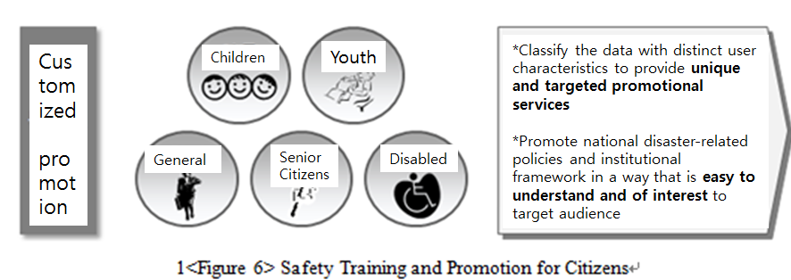
(3) Citizen Involvement in Disaster Prevention
Citizens can access a web-based community flood map and/or social networking to view the information on disasters and learn what to do in an emergency. They can see the damage in real time and share their ideas online. Public servants are dispatched to the flood-prone areas to help the citizens protect themselves. The public and private sectors work together to hold training sessions to ensure efficiency in rescue and restoration. Input from experts and citizens is encouraged, to identify the most effective and simplest resolution to flood damage. There is also a safety governance system at the dong district level. The citizens are encouraged to take part in the project of building a safe town, which is designed as part of the disaster prevention system. In the event of a crisis, the private sector, military, police, and all other available manpower and equipment are utilized for restoration and security. To operate this system, Seoul is developing disaster management governance that will involve all relevant authorities and private organizations.
A City Enriched by the Natural Circulation of Water
Seoul adopted a water circulation system to restore natural water circulation and increase the amount of rainwater absorbed into the ground. This type of new rainwater management is critical as it eases the burden on the existing sewage system and rainwater pumping stations, and helps the city to be more prepared for urban flooding. In 2006, Seoul became the first city in South Korea to enact an ordinance on the management of rainwater. To date, the city has installed facilities that store and utilize rainwater, and plans to install more. Government offices are assisted in improving the permeability of road pavement and parking lots, and citizens are supported in installing small and simple devices that enable them to make use of the rainwater. The water circulation system is expected to reduce the ‘heat island’ effects and help the ground absorb and store the rainwater when it rains. This is all expected to help with the urban flooding issue.
Overseas Applicability
The focus of Seoul’s flood control policy is on adapting to climate change and enhancing the city’s responsiveness to flooding. In order to achieve this goal, the city has improved its basic disaster prevention facilities and upgraded their 10-year frequency to a 30-year frequency. The city has also revised its rigid, physical facility-oriented approach to ensure that its policy is tailored to the needs of the local districts, each with different geographical and environmental features and vulnerabilities. Seoul has also reinforced its crisis response system of utilizing the latest systems and available manpower. It conducts simulations and training to facilitate the restoration process quickly in case of an actual incident. Citizens are encouraged to take part in the disaster prevention efforts In a crisis occurs, the private sector, military, police, and all other available manpower and resources are utilized to restore the damage as soon as possible. To operate this system, Seoul is establishing disaster management governance that will involve the relevant authorities and private organizations.
Application of Disaster Prevention Measures from the Beginning of Urban Development
Due to climate change, torrential downpours intensify and become more and more frequent, easily exceeding the capacity of the drainage system. Naturally, the road surface runoff quickly floods the roads and districts, threatening the lives of the citizens and damaging their property. Because of potential accidents, congestion and other risks, it is crucial that the districts are structurally well-designed from the beginning, so as to ensure that the surface runoff from roads, buildings, etc. is stored for a certain time and then expelled without flooding. Furthermore, flood gates and other facilities must be made mandatory at existing buildings with underground parking and entrances. In areas where flooding is a concern, there is an effort to regulate the use of underground space for residences. As such, the cities and countries where development is underway could refer to Seoul’s model to introduce the concept of disaster prevention where there are concerns of flooding, from the very beginning of urban development.
Disaster Management Governance Involving the General Public
In the past, Seoul mostly focused on building facilities and implementing government-led measures. However, that approach was limited in its effectiveness against extreme weather change, and the city needed a new paradigm.
Seoul developed a web-based community map showing flood data and utilized social networking (e.g., Twitter). Citizens can access the map or social networking to view and share information on the disaster in real time and learn what to do in an emergency. There is also a safety governance system at the dong district level. Citizens are encouraged to take part in the project of building a safe town, which is designed to constitute part of the disaster prevention system. In case of a crisis, the private sector, military, police, and all other available manpower and equipment are utilized for restoration as quickly as possible, as part of the disaster management governance involving the relevant authorities and private organizations. With the help of the citizens and all the available manpower and resources, the flood damage could be minimized and the city could stay safe. This could and should be the underlying principle of flood control governance.
References
Seoul Metropolitan Government, 2013, Study on Seoul’s Vision & Strategies for Flood Disaster.
Seoul Metropolitan Government, 2012, 2011 Flood Disaster White Paper.
Seoul Metropolitan Government, 2002, 2001 Flood Disaster White Paper.
Seoul Metropolitan Government, 2004, Water Reclamation Master Plan.